Reventazón River rafting: what remains after the dam
Is the Reventazón still raftable?
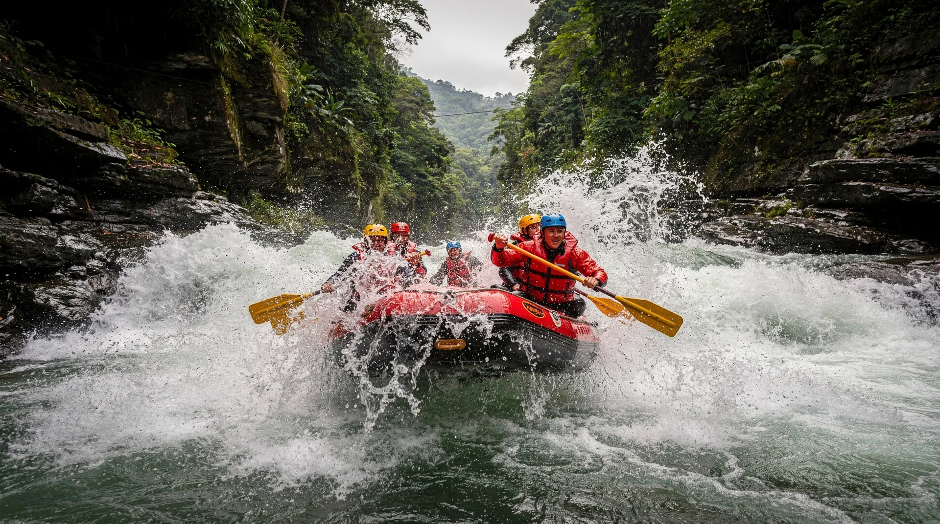
Yes, the downstream sections below the Reventazón Hydroelectric Dam (commissioned 2016) still offer Class III rafting. The legendary upper Class IV-V El Bajo and El Tucán sections were lost to the reservoir created by the dam.
The Reventazón: a river transformed by a dam
The Río Reventazón was once considered alongside the Pacuare as one of Costa Rica’s two great whitewater rivers. Through the 1980s and 1990s, the river drew serious paddlers from across the world to its Class IV-V upper sections: El Tucán, El Bajo, and El Imperial — names that carried weight in the global kayaking community.
In 2016, the Instituto Costarricense de Electricidad (ICE) commissioned the Reventazón Hydroelectric Project, the largest dam ever built in Central America by generation capacity. The dam flooded the canyon that contained the river’s best technical sections. El Bajo and El Tucán disappeared beneath the reservoir. El Imperial, which had already been partially compromised by an earlier dam at Cachí, was further diminished.
What remained was the downstream section below the dam: still a flowing river, still rafting terrain, but categorically different from the river it had been.
This guide gives you an honest picture of what the Reventazón offers today, why it still has value as a rafting destination, and who it suits.
What the Reventazón offers today
The downstream section: Class III
The section below the Reventazón dam, running approximately from the Angostura reservoir outlet toward the town of Siquirres, offers continuous Class III whitewater with a handful of Class III+ features at higher water levels. The water is clear (dam releases upstream provide consistent if regulated flow), and the surrounding vegetation is lush Caribbean-slope jungle.
It is an honest Class III river. The rapids are engaging without being dangerous for competent beginners. The scenery is pleasant without being spectacular. For context: the Sarapiquí’s upper section is comparable in difficulty and arguably more biodiverse in its riverbank wildlife.
The Reventazón downstream section is most often offered as part of combined Turrialba-area packages — a morning on the Reventazón followed by an afternoon cultural visit to the Guayabo National Monument (Costa Rica’s most significant pre-Columbian archaeological site, 8 km from Turrialba) makes a well-rounded full day.
Pacuare River rafting (from Turrialba) — from $120Turrialba-based operators who run the Pacuare also typically offer Reventazón day trips as a lower-intensity alternative. Price: approximately $70-90 per person.
The historical context: what was lost
For context on what the dam removed: the El Bajo section of the Reventazón was a Class IV-V run through a narrow, steep-walled canyon with continuous technical rapids and extremely limited bank access. It required experienced kayakers or very capable commercial rafters. The International Rivers organisation and Ríos Tropicales (the operator) fought the dam project for years, arguing that the ecotourism and commercial rafting value of the free-flowing river exceeded its hydroelectric value — a case that was ultimately unsuccessful.
The controversy around the Reventazón dam became a significant moment in Costa Rica’s complicated relationship between renewable energy development and ecological conservation. The country’s hydroelectric sector provides roughly 80% of its electricity, and the Reventazón addition was central to ICE’s decarbonization goals. The environmental cost was real and documented.
Who should raft the Reventazón
Choose the Reventazón if:
- You are based in Turrialba and want a half-day of Class III rafting without the logistics of a Pacuare or Sarapiquí day trip
- You are combining a river experience with a Guayabo Monument visit
- You have children aged 8-12 for whom Class III is appropriate but Class IV is too much
- You want to understand the dam’s impact on the river landscape (there is a genuine educational dimension here — guides can explain the pre-dam and post-dam river)
Choose the Pacuare instead if:
- You want the best available whitewater in the Turrialba region — the Pacuare put-in is 45 minutes from Turrialba and the river is incomparably better
Choose the Sarapiquí instead if:
- You want Class II-III rafting with excellent wildlife viewing in a more biodiverse corridor
The broader Turrialba region
Turrialba itself is an often-overlooked destination that merits a night or two if you are choosing the Pacuare and want to avoid the long San José day-trip structure. It is a compact town in the Reventazón valley, surrounded by coffee farms and sugarcane fields, with Volcán Turrialba looming above (currently under access restrictions due to volcanic activity — check OVSICORI for current status before planning a visit).
The Turrialba region offers:
- Pacuare River (45 min): Costa Rica’s premier Class III-IV run
- Guayabo National Monument (8 km): Pre-Columbian city with mounds, aqueducts, and petroglyphs — the most significant archaeological site in Costa Rica
- Reventazón downstream (15 min): Class III accessible rafting
- Coffee region: The high-altitude Turrialba valley produces excellent Arabica coffee, and several farms offer tours
For visitors planning the extreme adventure routes circuit, Turrialba works well as a 1-2 night base for the Pacuare portion before continuing to La Fortuna.
The dam debate: understanding the context
The Reventazón dam situation is worth understanding because it reflects a tension you will encounter elsewhere in Costa Rica: the country’s genuine commitment to renewable energy (targeting 100% renewable by 2050) sometimes conflicts directly with its ecotourism economy and biodiversity conservation goals.
The Reventazón project displaced 2,700 hectares of river corridor, affected indigenous Cabecar communities, and eliminated internationally recognised whitewater. ICE compensated with reforestation programs and community development funds, but the river sections are simply gone.
Ríos Tropicales, who ran the Reventazón commercially before the dam, redirected their focus entirely to the Pacuare — which is itself threatened by a proposed dam project that has been debated since the 1990s. Their ongoing advocacy for the Pacuare’s protection is partly motivated by watching the Reventazón’s fate.
Visiting the downstream Reventazón with a knowledgeable local guide is actually one of the more honest and contextually rich ways to understand Costa Rica’s environmental politics.
Practical information
Getting to Turrialba: From San José, Route 10 east. Drive time: approximately 1.5-2 hours. Regular bus service from San José’s Autotransportes Turrialba terminal ($3-4, 2 hours).
Rafting operators in Turrialba: Loco’s Aventura, Costa Rica Ríos, and the Turrialba-based teams of Ríos Tropicales and Desafio all operate in the region. Most will run either the Pacuare or the Reventazón downstream section depending on preference and group.
Best season: Year-round for the downstream section (dam releases provide consistent flow). May-November has higher flow; December-April is lower and clearer.
Accommodation in Turrialba: The Wagelia Hotel and Casa de Lis are solid mid-range options in town. Pacuare Lodge (accessible only by raft or helicopter) is the area’s luxury experience — see our multi-day Pacuare expeditions guide.
Turrialba town: a genuine destination, not just a transit point
Many visitors pass through Turrialba purely as a staging point for the Pacuare. This is a mistake. Turrialba is one of the more interesting small cities in the Central Valley — a university town (Universidad EARTH sits on the outskirts) with a lively agricultural economy, a good central market, and a food culture shaped by the surrounding coffee, sugarcane, and cheese-producing countryside.
Turrialba cheese: The valley produces a distinctive white semi-hard cheese (Queso Turrialba) that has received Designation of Origin status — one of only a handful of Costa Rican agricultural products with this protection. It is sold at the central market, in local tiendas, and at several farms that offer direct sales. Try it on fresh bread at the market for a genuine local breakfast.
Local sodas: The Turrialba central market area has several excellent sodas serving the agricultural workers who come into town for supplies. Soda Morales and the unnamed but excellent soda on the second floor of the market building serve typical Costa Rican breakfasts — gallo pinto, eggs, cheese, and coffee — for $3-5. This is as far from tourist-restaurant food as you can get while still being in a mid-sized Costa Rican city.
Volcán Turrialba: The volcano above the city has been in an eruptive cycle since 2014 and access to the summit crater has been restricted by OVSICORI (the national volcanological observatory). Check current access status before making plans. When the volcano is in low-activity phases, the lower slopes offer good hiking through cloud forest with views across the Caribbean lowlands. When activity is elevated, the volcano produces ash falls that occasionally reach the city — not dangerous but disruptive.
Guayabo National Monument: The archaeological site 8 km from town is the country’s most significant pre-Columbian site and genuinely underpopulated with visitors compared to its importance. Combine with the Reventazón or Pacuare rafting for a culturally complete Turrialba day.
Frequently asked questions about Reventazón River rafting
Can I still kayak the upper Reventazón sections?
No. The El Bajo and El Tucán sections are submerged under the reservoir. Some kayakers run creek sections above the dam in high water, but these are for expert Class V+ kayakers with full whitewater rescue experience, not tourist activities.
Is the downstream section worth it compared to the Pacuare?
Objectively, no — if you have time and budget for the Pacuare (which is 45 minutes further and $30-50 more expensive), the Pacuare is significantly better. The downstream Reventazón is worthwhile if Pacuare logistics do not fit your itinerary.
How long is the downstream rafting section?
The commercially rafted section runs approximately 8-14 km depending on operator access points and water levels. At typical flow, this means 2-3 hours on the water, making it better suited to a half-day than a full day.
Did the dam affect other wildlife beyond fish?
Yes. The flooded corridor affected mammals that used the riverside habitat (tapirs, peccaries, jaguar movement corridors), displaced bird communities from the inundated forest, and reduced the sediment flow to downstream agricultural land. The environmental impact assessment before construction was controversial — many ecologists argued it significantly underestimated long-term biodiversity costs.
Is there rafting year-round on the Reventazón?
The downstream section runs year-round due to regulated dam releases maintaining minimum flow. Unlike free-flowing rivers that can become too low in dry season, the Reventazón’s regulated flow actually makes it more consistent for commercial rafting than some unregulated options.
Guayabo National Monument: the Turrialba day’s second anchor
The Reventazón downstream section works best as a half-day activity paired with an afternoon cultural or historical experience. Guayabo National Monument — 8 km from Turrialba — is the obvious and genuinely excellent choice.
Guayabo is Costa Rica’s most significant pre-Columbian archaeological site. The city was occupied between approximately 1000 BCE and 1400 CE and supported a population estimated at 10,000-20,000 people at its peak — remarkably large for the pre-Columbian Americas outside of Mesoamerica and the Andean civilisations. The site preserves circular stone mounds (representing household and ritual structures), an aqueduct system that still carries flowing water after 1,400 years, causeway roads (calzadas) made of large river boulders, and petroglyphs including the famous alligator and jaguar carvings.
The SINAC-administered monument is relatively uncrowded even by Costa Rica standards. You walk through the site with a park guide (mandatory and included in admission, approximately $8-12 per person) along a well-maintained trail that gives access to the central precinct. The forest surrounding the site has been regenerating for decades — it is secondary cloud forest at 1,100 meters elevation, which means good bird diversity including toucans, trogons, and mixed flocks.
Allow 2-3 hours for Guayabo. Combined with the morning Reventazón downstream trip, this creates a full day from Turrialba that covers both river and cultural dimensions without overlap or rushing.
Turrialba’s coffee context
The Turrialba valley sits at 600-1,200 meters elevation on the Caribbean slope of the Cordillera Volcánica Central — conditions ideal for high-quality Arabica coffee. The valley produces distinctive coffees with characteristics quite different from the Tarrazú and Central Valley coffees that dominate Costa Rica’s export profile: Turrialba beans tend toward lighter, fruitier cups with good acidity, reflecting the wetter, cloudier growing conditions.
Several Turrialba-area farms offer guided coffee tours that are considerably less commercialised than the major operations near San José (Doka, Britt, Hacienda Alsacia). The experience is more intimate — you visit a working farm rather than a purpose-built tourist plantation, and the farm owners are directly involved in the tours.
For a river-and-coffee day from Turrialba: morning Reventazón rafting (half-day), afternoon Guayabo Monument (2 hours), late afternoon coffee farm tour (1.5 hours), overnight in Turrialba. This structure gives you three distinct aspects of the region without rushing.
Conservation lesson from the Reventazón: what you can apply to other rivers
The Reventazón story has implications beyond the specific river. It represents a pattern of conflict between Costa Rica’s genuine need for renewable energy expansion and the ecological and tourism value of its rivers — a pattern likely to recur.
Several other Costa Rica rivers face similar development pressure:
The Pacuare has been the subject of proposed dam studies for thirty years. The dam has not been built partly because of organised resistance from Ríos Tropicales, conservation groups, and international river advocacy organisations. The economic value of the Pacuare as a rafting destination — estimated at $15-20 million annually to the national tourism economy — has been a significant argument in the anti-dam case.
The Río Celeste (feeding the famous blue waterfall in Tenorio Volcano National Park) has been threatened by upstream agricultural water extraction. Current protections are not absolute.
The Sarapiquí faces less dam development pressure but significant water quality pressures from agricultural runoff in its middle and lower sections.
Understanding these pressures gives river visits an additional dimension of meaning. When you choose to raft with an operator that contributes to river conservation advocacy, you are participating in an active conservation debate, not just an adventure activity.
Frequently asked questions about Reventazón River rafting (extended)
Is there anything to see from the river about the dam’s impact?
Yes. The Angostura dam creates a reservoir that is visible from certain points as you approach from the highway. The clear water line — where the reservoir’s submerged forest transitions to open water — is visible from elevated road sections. Guides knowledgeable about the dam’s history can point this out. The contrast between the reservoir above and the free-flowing river below is an instructive visual lesson in dam impact.
Has the downstream section been restocked with fish?
ICE funded a fish restocking program for the downstream Reventazón as part of the dam’s environmental mitigation requirements. Rainbow trout and native freshwater fish species were introduced. The downstream ecology is recovering but is significantly less diverse than the pre-dam river ecosystem. The flow regulation (consistent dam releases rather than natural flood-drought cycles) disrupts the nutrient cycling and habitat variation that native fish communities depend on.
Related guides
For the better whitewater option in the Turrialba region, our Pacuare River rafting guide is the essential read. The multi-day Pacuare expeditions guide covers the overnight lodge experience. For a full comparison of Costa Rica’s commercial rafting rivers by class and experience type, see rafting class comparison.