How to read Costa Rica tide tables and surf conditions
How to read CR tide tables?
IMN tide service, tide-x apps, surf schools brief daily.
Why tides matter more in Costa Rica than at most beach destinations
Costa Rica’s Pacific coast experiences a tidal range of 2.5-3.5 metres — among the largest in Central America. This is not academic. A beach that is 80 metres wide at low tide may be reduced to 20 metres at high tide, with the surf breaking closer to shore and the snorkel reef that was accessible at low tide now under 3 metres of water instead of 1 metre.
For snorkellers, the tidal cycle determines whether a site is accessible at all. The Cahuita reef in the Caribbean is best at mid-tide; too low and sections of coral are exposed and dangerous, too high and the surge makes navigation difficult. For surfers, the tide determines which breaks are working — many Pacific beach breaks are best at mid-tide, while reef breaks often work better at specific tide windows.
For families with children, the tide dictates whether a “beach” exists at all during the planned visit time.
This guide gives you the tools and knowledge to read Costa Rica’s tidal and surf conditions accurately before you commit to a beach day.
The official source: IMN tide tables
The Instituto Meteorológico Nacional (IMN) publishes official tide tables for Costa Rica’s main coastal stations. The website is imn.ac.cr — navigate to “Mareas” (tides) and select the nearest coastal station to your location.
The main reference stations for the Pacific coast are:
- Puntarenas: Central Pacific reference point
- Quepos: Central Pacific south
- Golfito: Southern Pacific / Osa
- Liberia / Bahía Culebra: Northern Guanacaste (approximated from the closest station)
For the Caribbean coast:
- Puerto Limón / Moín: Main reference station for the Caribbean
The IMN data gives tide times and heights in metres above mean low water. The Pacific has two tidal cycles per day (semi-diurnal), meaning two high tides and two low tides in approximately 24 hours, with the two highs typically being different heights (“mixed semi-diurnal” pattern).
How to read the table: Times are given in local Costa Rica time (no daylight saving). Heights are in metres. A reading of 3.2 metres is a high tide; 0.1 metres is nearly the lowest low tide. The range between high and low indicates how dramatic the tidal change will be.
Tide apps and online tools
The IMN website is accurate but basic. The following apps provide the same data in a more accessible format:
Tide-X: The most widely used tide app among Costa Rica beach visitors and surfers. Available for iOS and Android. Covers all Costa Rican coastal stations with graphical tide curves showing the day’s pattern at a glance. Also includes swell height and period data from NOAA wave buoys.
Tides Near Me: Simple graphical interface, useful for quick checks. Less detailed than Tide-X for swell information.
Magic Seaweed (MSW): Better for surf conditions than tides. Gives swell direction, height, and period for the Pacific coast with 7-day forecasts. Used by most serious surfers in Tamarindo, Nosara, and Santa Teresa. The surf quality rating system (stars out of 5) is a useful shorthand but should be verified locally.
Surfline: Premium surf forecasting service with Costa Rica-specific break data for major spots. The camera network at key breaks (Tamarindo, Nosara, Jacó) allows live surf checking. Subscription-based ($7.99/month) but genuinely useful for a surf-focused trip.
Windy.com: The best free tool for wind forecasting, which matters for Papagayo wind season (November-April) on the Guanacaste coast. The Papagayo offshore wind that creates dangerous conditions at northern Guanacaste beaches is clearly visible on Windy’s regional wind maps.
How surf schools brief conditions
At every surf destination in Costa Rica — Tamarindo, Jacó, Nosara, Santa Teresa, Sámara — licensed surf schools hold a daily briefing for their students that covers:
-
Current swell height and period: Usually from Magic Seaweed or Surfline. Swell height refers to the significant wave height offshore; actual breaking wave height at the beach is typically 60-80% of the offshore swell in most Pacific beach break conditions.
-
Tidal timing: Which stage of the tide is happening during the lesson window, and how that affects the break shape. Most Pacific beach breaks work best at mid-incoming tide — the school schedules lessons around this.
-
Wind conditions: Offshore wind (blowing from land toward sea) grooms the waves and produces clean faces. Onshore wind (from sea toward land) creates choppy, messy conditions. Morning sessions before sea breeze develops (which typically starts 10-11am) are cleaner than afternoon sessions.
-
Rip current locations: Instructors identify rip channels every morning from the beach and brief students on which areas to avoid.
If you are learning to surf in Costa Rica, this briefing is part of your tuition.
Jacó: beginners surf lessons — from $50 Tamarindo surf: learn and practice surfing — from $50Reading Pacific swell: what the numbers mean
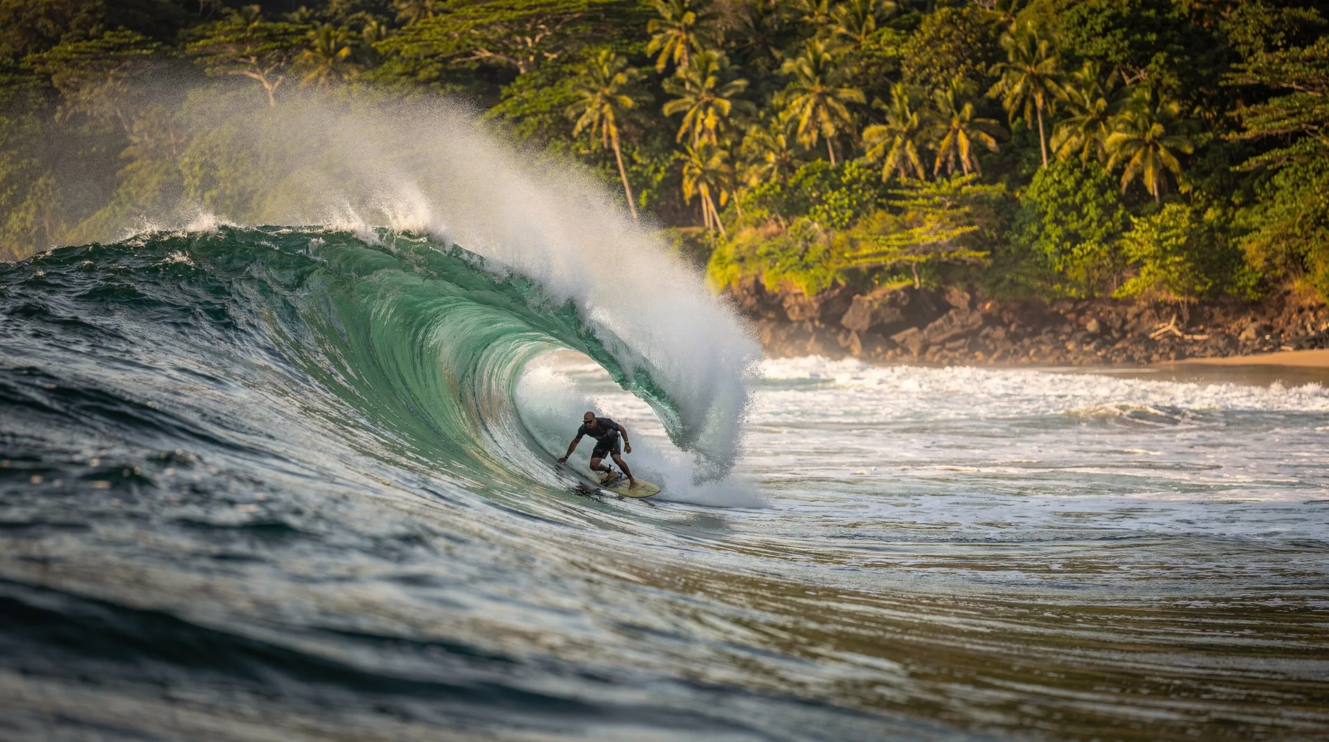
A surf forecast will give you numbers like: “Swell: 1.2m at 14s from 210°.” Here is what that means:
- 1.2m: The significant wave height offshore (average of the tallest third of waves). At the beach, this typically produces breaking waves of 0.8-1.5m (waist to head high).
- 14s: The wave period — seconds between successive waves. Longer period means more powerful, better-shaped waves. Under 8 seconds is choppy short-period wind swell. 12+ seconds is quality groundswell.
- 210°: The swell direction in degrees. South-facing beaches (Santa Teresa, Nosara, Dominical) work best with south swells (180-220°). West-facing breaks work with westerly swell (240-280°). Northwest swells (300-330°) power Tamarindo, Witch’s Rock, and Playa Grande in the dry season.
For non-surfers: Ignore the numbers and use the star rating on Magic Seaweed or ask your hotel reception “how are the waves today?” Local knowledge trumps any app.
The Caribbean coast: different pattern, different tools
The Caribbean coast of Costa Rica has a significantly smaller tidal range than the Pacific — typically 30-50 cm (versus 2.5-3.5m on the Pacific). This means tidal timing matters less for beach access on the Caribbean but still matters for reef snorkelling depth.
Caribbean swell comes from the north and northeast — trade winds and North Atlantic storm systems. The peak Caribbean surf season runs November through March. Swell forecasts for Puerto Viejo and Cahuita can be read from:
- Windguru (windguru.cz): Excellent Caribbean wind and wave forecasting. Better than Surfline for the Caribbean coast.
- IMN Limón station: For tide data.
- NOAA Atlantic wave models: For long-range Caribbean swell forecasting.
Caribbean snorkelling conditions (at Cahuita and Punta Uva) are best read via local operators who track water clarity daily. Call or message local snorkel operators the evening before your planned excursion — they will tell you whether conditions are suitable.
Seasonal patterns: when to plan beach activities
Pacific dry season (December-April)
Guanacaste (north): Generally calm mornings, Papagayo wind risk in the afternoon from January through March. Best beach time is 7am-11am. Northwest swells generate surf for Tamarindo and Playa Grande.
Central Pacific (Manuel Antonio, Jacó): Dry, sunny, calm. The best snorkel and catamaran season. Some south swell activity continues through March.
Nicoya Peninsula (Nosara, Santa Teresa): Dry season here means calmer, smaller surf. Wave quality is lower from December-March; best surf is April-October. Excellent swimming conditions at Sámara.
Pacific green season (May-November)
Guanacaste: Afternoon rains, but mornings often clear. South swells from May through October provide the best surf of the year for south-facing breaks (Nosara, Santa Teresa, Dominical). Fewer tourists, 20-40% lower prices.
Central Pacific: Rainiest months are September-October. Manuel Antonio can receive 400mm+ of rain in October. Beach days still happen; rain typically falls in the afternoon. The catamaran and surfing schedule shifts to morning sessions.
Osa Peninsula: Green season is the wettest here — Drake Bay receives over 5,000mm per year, mostly May-November. Beach activities are possible but require flexibility.
Caribbean windows
- September-October: The Caribbean “summer” — least rainfall, best visibility, ideal for Cahuita and Punta Uva snorkelling. Very few tourists.
- February-April: The main Caribbean dry window.
- November-January: Typically the roughest for Caribbean beaches — Atlantic swell and rain.
Practical tide planning for common activities
Family beach day (safe swimming): Visit at mid-tide to high-tide on a gently shelving beach. Low tide at calm beaches like Sámara can expose rocks and coral. At exposed beaches with high tidal range (Dominical, Espadilla Norte), high tide brings the surf closer to the dry sand — potentially dangerous.
Reef snorkelling: Mid-tide is optimal at most Caribbean reef sites. Low tide at Cahuita can expose and damage coral if you stand. Very high tide increases current through reef passages.
Whale tail sandbar (Uvita, Marino Ballena): The famous whale tail formation is only visible at low tide when the sandbar emerges. Check the low tide time for your visit date — a 1.0m low tide is typically sufficient for the sandbar to appear.
Rock pool exploring: Lowest low tides (spring tides around full and new moon) are the best time for tidal pools. Morning low tides are better than evening because light penetration is clearer.
Frequently asked questions about tide and surf conditions
How far ahead can I get reliable surf forecasts for Costa Rica?
Three to five days is reliable for most surf forecasting models. Seven-day forecasts are indicative only — treat them as likely patterns, not specifics. For trip planning, focus on which region has the highest surf probability during your visit dates rather than individual day forecasts.
What is the tidal range at Manuel Antonio?
The central Pacific at Quepos/Manuel Antonio has a tidal range of approximately 2.8-3.2 metres. The beach inside the park (Playa Manuel Antonio) is significantly reduced at high tide — plan your park visit around the mid-to-low tide window for the most beach access.
Do tide tables account for weather effects?
No — tide tables are astronomical predictions based on gravitational forces. Actual water levels can differ from predicted by 10-30cm due to barometric pressure changes and strong onshore or offshore winds. In practice, the error is rarely significant enough to affect planning.
What does “spring tide” mean?
Spring tides (not related to the season) are the larger tidal ranges that occur around full moon and new moon, when the sun and moon align. Costa Rica’s spring tides can have a range 30-50cm greater than average. Neap tides (around quarter moon phases) have the smallest tidal range. If you want to see the whale tail sandbar at Uvita or explore tidal pools, plan for a spring low tide.
Is there a free official Costa Rica tide app?
The IMN does not have a dedicated app, but their website (imn.ac.cr) is mobile-friendly and the tide data loads on most smartphones with an internet connection. Tide-X is free for basic functionality and covers Costa Rica stations. Surfline has a free tier with limited detail.
Do surf schools provide conditions reports in English?
Yes — all major surf schools at Tamarindo, Jacó, Nosara, Sámara, and Santa Teresa brief in English. Many also post daily condition summaries on their Instagram accounts, which can be found by searching for “[beach name] surf school” or checking the local surf break accounts.
Where to find more detail
For specific beach safety including riptide identification, see Costa Rica beach safety. For surf beach selection by level, see best surf beaches. For snorkel timing at Caribbean beaches, see best snorkel beaches.
For planning your beach trip itinerary, start with the best time to visit Costa Rica guide and cross-reference with the specific coast timing information in this guide.