Cerro Chirripó: summit guide for Costa Rica's highest peak
Complete guide to hiking Cerro Chirripó (3,821 m) — permits, Crestones Base Lodge, trail conditions, summit views, and everything you need to reach the top.
Top experiences nearby
Quick facts
- Best time to visit
- February – May and June – August (driest summit conditions)
- Days needed
- 3-4 days minimum (1 ascent day + 1 summit day + 1 descent)
- Getting there
- 3 hrs from San José to San Gerardo de Rivas by car
- Budget
- $595 guided tour; or $15/day permit + $35-45/night Crestones Base Lodge + equipment
The top of Central America’s southern half
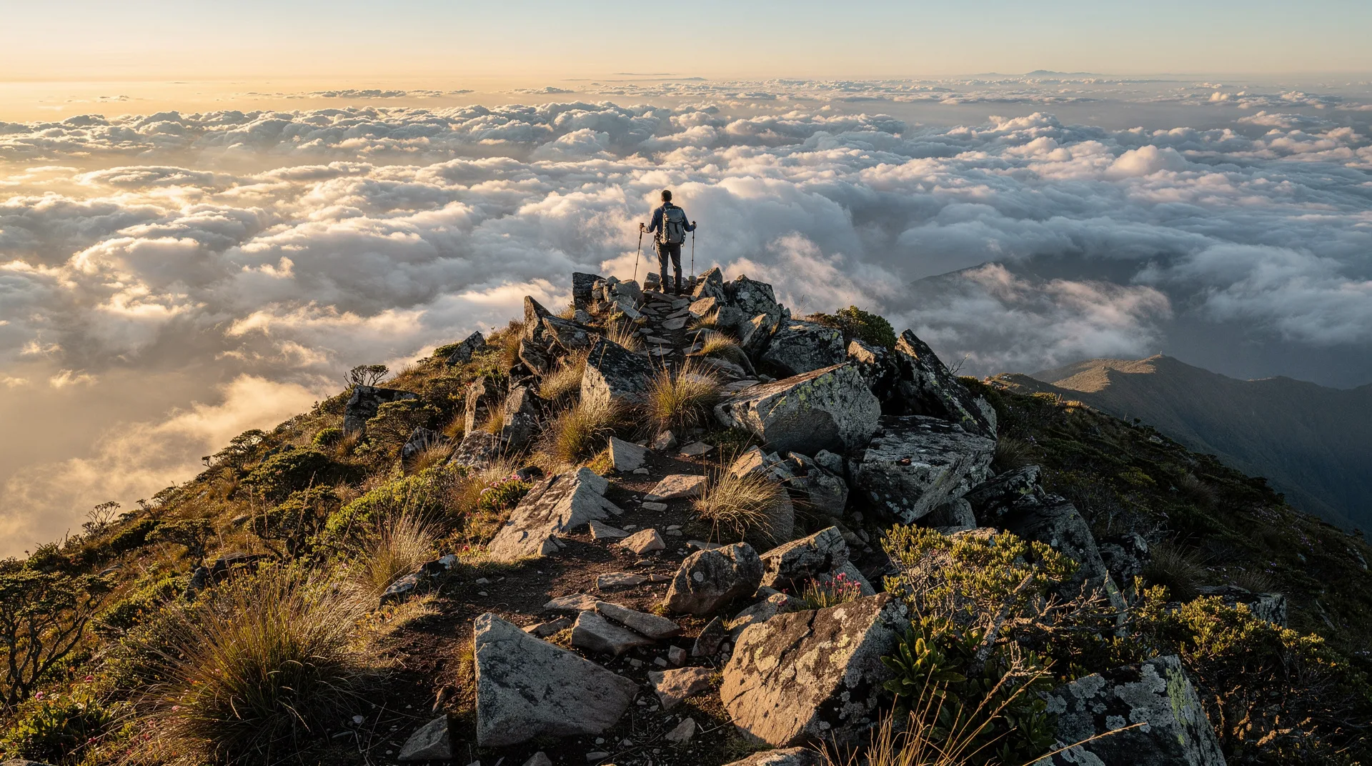
Cerro Chirripó rises to 3,821 metres above sea level, making it the highest peak in Costa Rica, the highest in Central America south of Guatemala’s volcán Tajumulco (4,220 m), and the sixth highest in the entire American isthmus. Standing on its summit on a clear morning, you can see both the Pacific Ocean and the Caribbean Sea simultaneously — the same experience as Irazú’s crater rim, but earned after 9-12 hours of ascent rather than a car ride.
Chirripó is not a volcano. It is a glacially sculpted granite peak in the Talamanca mountain range — a terrain shaped by ice-age glaciers that retreated around 10,000 years ago, leaving cirque basins, glacial lakes (the Lagos de Chirripó, now a series of high-altitude tarns), and the angular, exposed rock faces characteristic of glaciated terrain. The mountain sits within Chirripó National Park (50,150 hectares), which protects one of the most intact high-altitude ecosystems in Central America.
The journey to the top is legitimately difficult and requires serious preparation. This is not a managed volcano experience with a car park at 3,300 metres. It is an overnight wilderness trek that demands genuine fitness, proper equipment, and advance permit reservation.
The permit system and booking
SINAC (the National System of Conservation Areas) controls access to Chirripó through a mandatory online permit system. Permits are required for overnight stays at Crestones Base Lodge (the only accommodation on the mountain, at 3,400 m), and they sell out weeks or months in advance during peak periods. The booking process is as follows:
- Reserve permits at sinac.go.cr/chirripo — permits open at 8am Costa Rica time, typically 90 days in advance of the desired date.
- Peak season (December-April, July-August): expect permits to sell out within hours of opening. Less popular months (May, June, September-November) have more availability.
- Maximum 40 persons per day allowed on the mountain; maximum stay 4 nights per person per year.
- Permit cost: approximately $18 per person per day park fee + $35-45 per person per night at Crestones.
For those who cannot navigate the permit system independently, Cerro Chirripó tour: ascent to land of eternal waters — from $595 organises the complete Chirripó experience — permit, transport from San José, guide, lodge reservation, and meals — in a 4-day guided tour from approximately $595 per person. This is the simplest entry point for travellers unfamiliar with the permit system.
The trail and what to expect
The official route to the summit begins at the SINAC ranger station in San Gerardo de Rivas village (1,390 m elevation, 3 hours from San José by car). The trail is single-direction — up on the day of ascent, same trail back on descent.
Day 1 — Ascent to Crestones Base Lodge: The main ascent covers 14.5 kilometres and gains 2,000 metres in elevation from the ranger station to the lodge at 3,400 m. Strong hikers complete it in 7-9 hours; average pace is 9-12 hours. The terrain moves through cloud forest (the lower section is heavily shaded and sheltered), then opens into dwarf forest, then into the stark páramo — the Andean-style high-altitude grassland ecosystem unique to the Talamanca range. Above 3,000 metres, the vegetation changes dramatically: low, wind-pruned shrubs, cushion plants, and bare rock. The air thins perceptibly; altitude acclimatisation matters.
Day 2 — Summit attempt: Most hikers depart Crestones at 3-5am to reach the summit by sunrise (around 5:30-6am). The 3-kilometre summit route from the lodge gains another 420 metres. On a clear morning, the summit view takes in the Peninsula de Osa, the Pacific, the Caribbean, Volcán Arenal, and the entire Talamanca range. Clouds typically build before 10am, so early departure is essential.
Day 3 — Descent: The return to San Gerardo takes 6-8 hours on the same trail. Legs and knees bear the brunt of the descent; trekking poles are strongly recommended. Most guided tours include a vehicle transfer from the trailhead to San José on day 3.
What to bring
Mandatory gear:
- Hiking boots with ankle support (not trail runners)
- Trekking poles (strongly recommended; the descent is brutal without them)
- Headlamp with spare batteries for the pre-dawn summit push
- Sleeping bag rated to at least 0°C (Crestones can reach -5°C in dry season at night)
- Warm layers: fleece + waterproof shell jacket (summit wind chill can drop perceived temperature to -10°C)
- Rain gear
- 2-3 litres of water carrying capacity; filtration tablets or a filter
Food: Crestones Base Lodge provides basic meals (included in most guided tours; self-cookers can use the lodge kitchen). The lodge sells basic snacks at elevated prices. Bring trail food for the ascent: energy bars, nuts, dried fruit, and something substantial for lunch on the trail.
Physical preparation: Chirripó is appropriate for adults in good cardiovascular fitness. The key is not speed but stamina over 9-12 hours. If you regularly hike more than 15 km with elevation, you are likely ready. If you have never hiked more than 6-8 km in a day, Chirripó is not the right first mountain.
The páramo ecosystem
The high-altitude páramo above 3,000 metres is ecologically unique in Costa Rica — the only instance in the country of this Andean ecosystem, which occurs naturally from Colombia and Venezuela through Ecuador. It supports plant species found nowhere else in Central America: dwarf palms (Ceroxylon alpinum relatives), espeletia-like rosette plants, and a remarkable diversity of orchids and bromeliads clinging to exposed rock.
Wildlife in the páramo is sparse but memorable. Volcano junco (a high-altitude sparrow found only above 3,000 m in the Talamanca range) is common around the lodge. Resplendent quetzals have been recorded above 3,200 m. White-tailed deer occasionally traverse the open grassland. The glacial lakes host no fish (too acidic and cold) but support aquatic insects and occasional duck species.
San Gerardo de Rivas: the access village
San Gerardo de Rivas (not to be confused with San Gerardo de Dota — the quetzal valley further north) is the trailhead village — a small community at 1,390 m with a cluster of basic lodges, restaurants, and gear rental shops catering entirely to Chirripó hikers. Accommodation here serves primarily as a pre-ascent night, allowing a 4:30am departure for the first day. Basic guesthouses cost $25-45 per person including breakfast.
The village is 20 kilometres south of the Pan-American Highway via a paved road through Pérez Zeledón. From San José, the drive takes approximately 3 hours (230 km) via the San Isidro de El General junction. Travellers combining Chirripó with the rest of San José province often overnight in Pérez Zeledón before driving to the trailhead. The Chirripó National Park guide covers the full logistics and permit system in depth.
Frequently asked questions about Cerro Chirripó
Do I need a guide to climb Chirripó?
No — unlike Corcovado, a certified guide is not mandatory for Chirripó. The trail is well-marked and regularly used. However, first-time visitors who are unfamiliar with altitude hiking and the permit system often find that an organised tour (covering logistics, transport, and a guide who knows the trail conditions) removes significant friction. Solo hikers with trail experience and a booked Crestones permit are fully capable of summiting independently.
What is the hardest part of the Chirripó hike?
The final kilometre before the pass known as Los Crestones, where the trail climbs steeply over granite slabs above 3,500 metres, is the section where altitude effects become most pronounced. Most hikers experience some degree of breathlessness, mild headache, or fatigue above 3,200 m. Moving slowly, drinking water regularly, and not racing the clock are the best strategies.
How cold does it get on the mountain?
Crestones Base Lodge sits at 3,400 m — temperatures at night range from 0 to -5°C in the dry season (January through April) and 3 to 8°C in the rainy season. A sleeping bag rated to 0°C or below is essential for dry-season visits. The summit at dawn can feel significantly colder due to wind; bring gloves and a hat.
Is Chirripó ever closed?
The park can close due to wildfires (which occur on the páramo in severe dry years) or extreme weather. Check SINAC’s official channels before your trip. The permit system itself creates de facto capacity management that prevents overcrowding on the trail.
Where to go next
From the Chirripó access area, Pérez Zeledón is the main service town 20 km north. San Gerardo de Dota is 60 km north on the Pan-American Highway — a natural pairing for a combined mountain adventure and quetzal-watching trip in San José province. Heading south from Pérez Zeledón, the Costanera Sur highway leads toward Uvita and the southern Pacific coast.