Pérez Zeledón: gateway to the southern highlands
Pérez Zeledón (San Isidro de El General) — the service hub for Cerro Chirripó hikers, the Osa Peninsula corridor, and Costa Rica's least-touristed valley.
Top experiences nearby
Cerro Chirripó tour: ascent to land of eternal waters
From San José: Pacuare River white water rafting day trip
Pacuare River full-day rafting adventure from San José
San Jose: Sarapiqui Class 2&3 rafting adventure
San Jose: Sarapiqui Class 3&4 rafting to La Fortuna
San Jose: Manuel Antonio National Park tour
Quick facts
- Best time to visit
- Year-round; February – April ideal for Chirripó access
- Days needed
- 1 day as transit/supply stop; 2-3 if combining with Chirripó or San Gerardo
- Getting there
- 3 hrs from San José by car; 3.5 hrs by Tracopa/Musoc bus
- Budget per day
- $40-80 per person; significantly cheaper than tourist beach zones
The honest gateway city
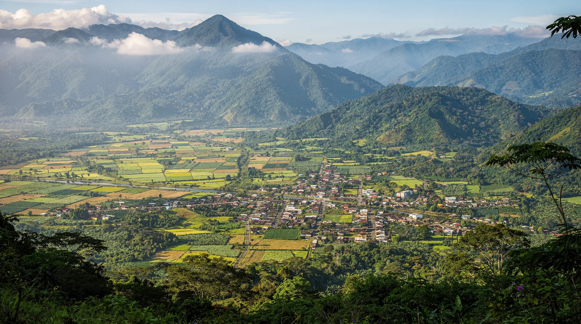
Pérez Zeledón is not on most travel itineraries, and it makes no apology for that. The canton, whose administrative capital is officially named San Isidro de El General (and universally called just “San Isidro” by Ticos), is the commercial and service hub of the General Valley — a broad agricultural plain that runs between the Talamanca range to the east and the Fila Costena mountains to the west, fed by the Río General and dozens of tributaries flowing from the Chirripó massif.
Travellers encounter Pérez Zeledón almost by necessity rather than by choice: it sits astride the Pan-American Highway at the critical junction where anyone heading south from San José diverges toward Cerro Chirripó (east, toward San Gerardo de Rivas), the Osa Peninsula (southwest, via Palmar Norte and Puerto Jiménez), or toward Uvita and the Marino Ballena whale coast (southwest via the Costanera). It is, in the most useful and least romantic sense, a crossroads city with genuine services.
What San Isidro de El General offers
San Isidro (population approximately 45,000 in the urban core) functions as a regional agricultural market and transport hub. The weekly farmers’ market on Saturdays near the central park is one of the largest and most authentic in Costa Rica outside San José — pineapple, papaya, cheese, raw honey, artisanal sugarcane products (tapa dulce), and dried beans from the surrounding farms fill the stalls. Prices are 40-60% lower than in San José or any tourist beach zone.
The central park itself is pleasant — a large shaded square with the standard colonial church and the usual cast of Tico daily life: schoolchildren, market vendors, old men reading newspapers. The city has several clean midrange hotels ($40-70/night), a handful of banks (BAC and BCR have ATMs that reliably accept foreign cards), a large supermarket (Megasuper), and a gas station — all of which become important for Chirripó hikers loading up on supplies.
The Chirripó connection
For travellers planning to climb Cerro Chirripó, Pérez Zeledón is the last major supply point before the mountain. The small town of San Gerardo de Rivas (the actual trailhead) is 20 kilometres east of San Isidro on a paved road. Most hikers spend the night in San Isidro or San Gerardo de Rivas the night before their ascent to allow a 4:30am start.
In San Isidro, you can stock up on: trail food (energy bars, nuts, dried fruit — from Megasuper), last-minute gear items (pharmacies carry blister care and basic first aid), and confirm your Crestones Base Lodge reservation at the SINAC office near the central market. The SINAC ranger station at San Gerardo de Rivas issues final park permits and checks equipment; arrive at least 30 minutes before your planned departure.
Guided Chirripó tours that include transport from San José typically stop in San Isidro for breakfast on the way to the mountain. Cerro Chirripó tour: ascent to land of eternal waters — from $595 covers the full 4-day ascent experience from San José with all logistics organised.
The General Valley: for independent travellers
The broader General Valley around Pérez Zeledón is one of Costa Rica’s most authentically agricultural landscapes — coffee and pineapple plantations on the valley floor, cloud-forest clad mountains on the eastern horizon, and scattered Tico communities whose relationship with the natural environment is based on farming rather than tourism. The valley lies within San José province and connects south toward Puntarenas province via the Costanera Sur.
A day’s exploration of the valley floor reveals:
Río General swimming holes — the river has several accessible swimming spots near the Pan-American Highway. Ticos picnic here on weekends; the water is clear and cool. Ask locally for the “poza azul” nearest to town.
Local coffee culture — the cantons of Pérez Zeledón and neighbouring Tarrazú (accessible via a mountain road east of San Isidro) produce some of Costa Rica’s most highly rated specialty coffees. Several small producers sell directly from the farm gate during harvest season (October through February). The cooperative Coopetarrazú in Santa María de Dota (40 km northeast via mountain road) offers farm tours and a cupping room.
Rivas and the Chirripó foothills — the paved road from San Isidro to San Gerardo de Rivas passes through increasingly dramatic mountain scenery as it climbs toward the trailhead, offering views of the Talamanca peaks that most visitors see only from the summit.
As a transit point for the Osa Peninsula
From Pérez Zeledón, the Costanera Sur (Route 34) runs 90 kilometres southwest to Palmar Norte, which sits at the junction for routes south toward the Osa Peninsula and Drake Bay. This coastal highway route is the standard road connection between San José and the Osa Peninsula — well-paved, fast (under normal conditions), and significantly more scenic than the inland alternative via Interamericana.
From Palmar Norte, the route to Puerto Jiménez takes an additional 80 kilometres on a road that becomes progressively rougher. Drake Bay requires a boat connection from Sierpe. Sansa domestic flights from San José directly to Puerto Jiménez (40 minutes) and Drake Bay (25 minutes) bypass this drive entirely for travellers without a rental car. The 12-day South Pacific deep itinerary covers the full Uvita → Drake Bay → Puerto Jiménez → Cerro Chirripó circuit that begins in this corner of the country.
Getting there and getting out
By bus: Tracopa and Musoc operate frequent services from San José’s Coca-Cola terminal and Tracopa’s own terminal on Calle 5 to San Isidro de El General. Journey time: 3.5-4 hours, $8-10 per person. Buses run approximately every 30-45 minutes from 5:30am.
By car: Route 2 (Pan-American Highway) south from San José. The route climbs over the Cerro de la Muerte (Mountain of Death, 3,335 m — the name refers to historic deaths of travellers crossing before the road was paved). On foggy days the crossing requires headlights and patience; allow 3 hours. Fill up with petrol before departing San José; the Cerro de la Muerte section has no service stations.
Onward connections: San Isidro has bus connections to Uvita (1 hour), Dominical (1.5 hours), Puerto Jiménez (2.5 hours), and San Gerardo de Rivas (1 hour). Taxis to San Gerardo de Dota junction (El Empalme) for the quetzal valley take about 30 minutes.
Frequently asked questions about Pérez Zeledón
Should I stay a night in Pérez Zeledón or just pass through?
For most travellers, a day stop or overnight transit is sufficient. The city has good services and is more affordable than tourist destinations, but the surrounding attractions (Chirripó, San Gerardo de Dota) are the draw rather than the city itself. Stay a night if you arrive late or have an early Chirripó departure; otherwise treat it as a practical stop.
Is the drive over the Cerro de la Muerte safe?
The road is paved and well-maintained, but the crossing at 3,335 metres involves dense fog common from May through November, cold temperatures, and occasional rain. Drive with headlights on, maintain lower speeds in zero-visibility sections, and never pass on blind corners. The road is marked with reflectors on the worst fog sections. In clear conditions (December through April mornings), the panoramic views from the summit are among the best on any road in Costa Rica.
Are there things to do in Pérez Zeledón beyond logistics?
The Saturday farmers’ market, the river swimming holes, and the mountain road to Tarrazú coffee country are all worthwhile for travellers with time. The Valle de El General canyon viewpoints accessible on local hiking trails above town are visited almost exclusively by Ticos — a rough but rewarding half-day excursion. For a full-day experience from the city, the drive to San Gerardo de Rivas and back provides excellent mountain scenery even without climbing Chirripó.
What is the nightlife or restaurant scene like?
San Isidro has a functional restaurant and bar scene catering to Tico rather than tourist tastes — sodas serving casados for $4-6, a handful of pizza restaurants, and several bars around the central park. Nightlife is low-key. The Saturday evening around the market area has the most energy. This is not a nightlife destination; visitors seeking that are better placed in Jacó or Tamarindo.
Where to go next
From Pérez Zeledón, the most common routes are northeast to San Gerardo de Dota and the quetzal valley (40 km, 45 minutes via the Pan-American), east to Cerro Chirripó via San Gerardo de Rivas (20 km), and southwest to Uvita and the Marino Ballena coast (90 km via Costanera). The city marks the southern boundary of San José province and the beginning of the road into the vast Puntarenas province southern zone.