12-day south Pacific Costa Rica: Uvita, Drake Bay, Osa, and Chirripó
The deep south: Costa Rica’s wildest corner
Most Costa Rica itineraries stop at Manuel Antonio and call it “the south.” This itinerary goes further — to the region where the jungle is genuinely impenetrable, the wildlife is wild rather than habituated, and the infrastructure deliberately minimal. The south Pacific coast (Uvita, Drake Bay, Puerto Jiménez) and the Chirripó highlands together form the most ecologically significant and least-visited section of Costa Rica’s tourist geography.
Marino Ballena National Park in Uvita protects the largest humpback whale sanctuary in Central America — the only place in the world where humpback populations from both hemispheres overlap. Corcovado National Park on the Osa Peninsula contains an estimated 2.5% of the world’s biodiversity in 424 square kilometers. Cerro Chirripó at 3,821 meters is Central America’s second-highest summit — a genuinely demanding multi-day hike that rewards with above-cloud dawn panoramas.
This is not a polished resort itinerary. Accommodation in Drake Bay is eco-lodge level; Chirripó requires sleeping in a mountain hut at 3,400 meters. The experiences are proportionally extraordinary.
Total estimated budget: USD 2,500–5,000 per person for 12 days, excluding international flights.
At a glance
| Stat | Value |
|---|---|
| Total days | 12 |
| Best for | Adventure travelers, wildlife enthusiasts, serious hikers |
| With/without car | Yes — 4WD essential for Osa routes |
| Budget range | USD 150–300 per person per day |
| Best season | December–April (dry, Corcovado and whale accessible); August–October (whale peak) |
| Physical requirement | Chirripó: 14–16 km climb, 2,500m elevation gain. Serious fitness required. |
Day-by-day breakdown
Days 1–2: Uvita and Marino Ballena National Park
Drive from San José to Uvita along the Costanera Sur coastal highway — one of Costa Rica’s best road experiences, hugging the Pacific south through Jacó and Dominical with sea views for 80 km. Allow 3 hours from San José to Uvita.
Uvita is a small, laid-back town at the edge of Marino Ballena National Park — not a resort town but a genuine working village that happens to have one of the world’s great whale nurseries offshore. The park protects the famous Whale Tail formation — a tombolo of sand and reef that appears at low tide in the shape of a whale’s fluke, visible from the headland trail.
Day 1: arrive, check in, and walk the Whale Tail at low tide. The park entry ($19 adults) includes access to the beach and the coastal trail. The sand formation is best photographed from the headland hill at the north end of the park — a 20-minute walk.
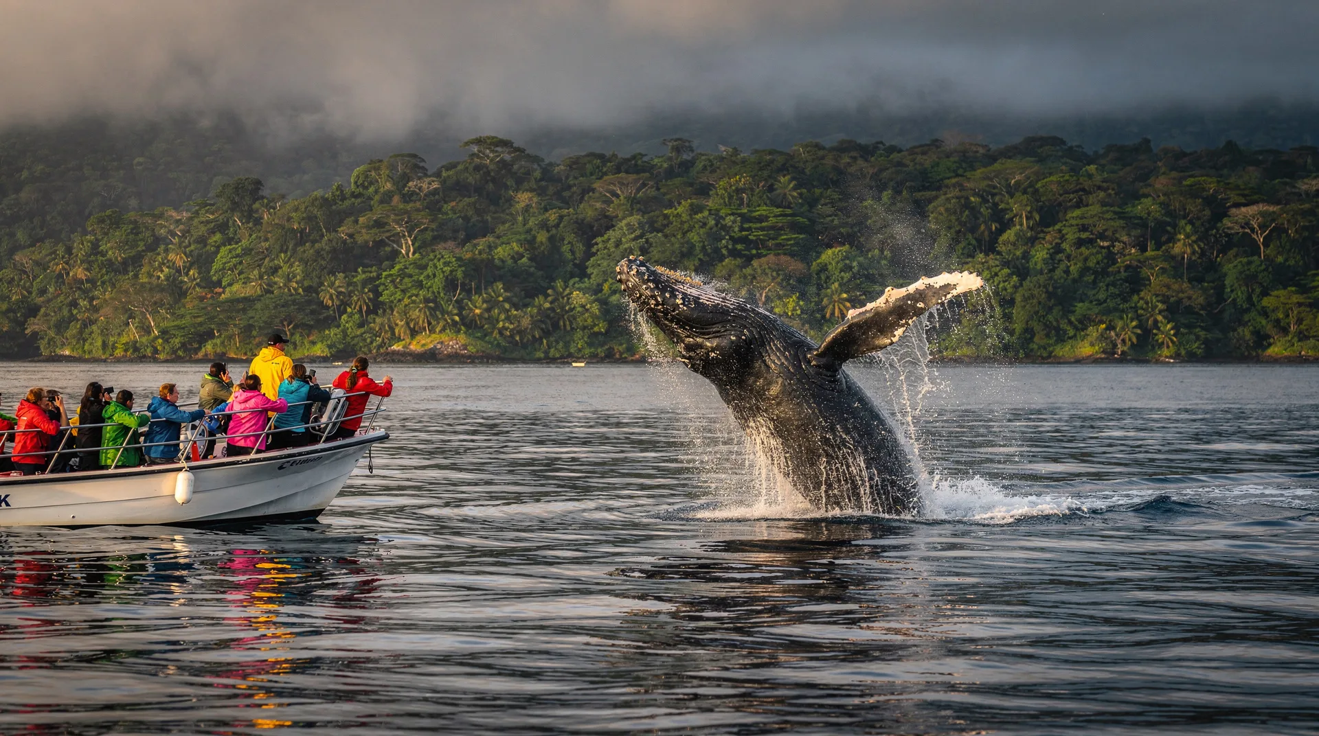
Day 2: whale watching boat tour — the centerpiece of any Uvita visit. Humpback whales (August–October south season; December–March north season) come within extraordinary proximity of the boats. Dolphins — spinner, bottlenose, and occasionally false killer whales — are present year-round.
Whale & dolphin watching in Uvita — from $75 Marino Ballena: whale watching in Uvita — from $80The same boat often visits a nearby rocky islet for snorkeling — calm, clear water with good reef fish coverage. Afternoon: Caño Island day trip pre-booked for Day 3, or use the afternoon to visit the Uvita waterfall (a 10-minute walk from town, free with a guide, entry $5 self-guided).
Stay: Oxygen Jungle Villas (mid-range, from $130/night, ocean-view infinity pool, excellent location above the park) or La Cusinga Lodge (luxury, from $200/night full-board, conservation-focused, extraordinary views).
Days 3–4: Drake Bay and Caño Island
Drive from Uvita south to Sierpe (about 1.5 hours), then take the boat up the Sierpe River and across the open Pacific to Drake Bay — a 1.5–2 hour boat journey that passes through mangrove estuary and ocean swell. This water entry into Drake Bay is a genuine experience: the mangroves give way to open Pacific, and the first view of the Osa Peninsula arriving by sea captures something of what the early naturalists felt.
Day 3: arrive Drake Bay and settle into your eco-lodge. Afternoon: walk the coastal trail toward Río Claro — scarlet macaws roost in the palms above the shoreline in large numbers (the Osa Peninsula has the highest density of scarlet macaws in the world). Green and black poison dart frogs are visible on the trail edges.
Drake Bay: bird watching tour — from $95Day 4: Caño Island biological reserve — a full-day boat trip from Drake Bay to Costa Rica’s most diverse marine reserve. Snorkeling over the coral gardens (visibility routinely 15–20 meters in dry season) delivers sea turtles, white-tipped reef sharks, eagle rays, and coral formations that survived the 1983 bleaching event. Humpback whales occasionally surface within sight of the island in season.
Caño Island Biological Reserve - snorkeling or diving — from $140Stay: Aguila de Osa Inn (mid-range, from $150/night, hillside cabinas above the bay, excellent guides) or Casa Corcovado Jungle Lodge (luxury, from $280/night full-board, right at the Corcovado border, outstanding guiding).
Days 5–6: Corcovado National Park
Corcovado requires a certified guide — no exceptions. Guides must be ICT-registered; arrangements can be made through your lodge or through operators in Drake Bay or Puerto Jiménez. The day trip from Drake Bay enters via San Pedrillo station (northernmost entrance) by boat at dawn.
Day 5: full-day Corcovado guided hike. San Pedrillo station: the Río Claro trail runs through lowland primary rainforest where all four of Costa Rica’s monkey species (howler, spider, capuchin, squirrel) can be seen in a single morning. Tapirs cross the trails near water sources. Baird’s tapirs — the largest land mammal in Central America — are shy but regularly encountered by experienced guides who know their routes.
Drake Bay: Corcovado NP and Sirena Station tour — from $135Day 6: optional second Corcovado entry (Sirena station, reachable only by boat or charter flight — longer hike, deeper forest, higher probability of encountering large fauna including pumas and jaguars, though sightings are rare). Many visitors spend Day 6 on a dolphin and whale watching tour in Drake Bay’s marine zone.
Drake Bay: dolphin and whale watching tour — from $120Days 7–8: Puerto Jiménez and Osa Peninsula
Boat from Drake Bay south around the Osa Peninsula to Puerto Jiménez — a 2-hour journey along one of the most dramatic coastlines in Central America. Alternatively, drive the Osa Peninsula road from Rincón via La Palma, roughly 3.5 hours.
Puerto Jiménez is the Osa Peninsula’s main town — small, functional, and a good base for the southern section of Corcovado (La Leona and Los Patos stations are accessible from here).
Day 7: Puerto Jiménez chocolate tour — several local cacao farms around the town offer hands-on tours covering cultivation, fermentation, roasting, and tasting. The Osa Peninsula’s cacao is organically grown and some of the finest in Central America.
Puerto Jiménez: chocolate tour — from $45Afternoon: mangrove kayak in the Golfo Dulce — the gulf between Puerto Jiménez and Golfito is one of Costa Rica’s most intact marine environments. Spinner dolphins, seahorses, and sea turtles inhabit the gulf’s calm waters.
Day 8: transfer from Puerto Jiménez back toward San José — drive north via Palmar Norte and then east toward San Isidro de El General. This journey from the Osa Peninsula back to civilization takes 4–5 hours; San Isidro is the staging town for the Chirripó ascent.
Stay (Puerto Jiménez): Iguana Lodge (mid-range, from $120/night, beachfront, excellent restaurant, good guiding network).
Days 9–11: Cerro Chirripó — summit ascent
Cerro Chirripó at 3,821 meters is Central America’s second-highest peak and Costa Rica’s highest. The summit hike is one of the country’s most demanding and most rewarding experiences — a 14 km climb from San Gerardo de Rivas trailhead, gaining 2,500 meters in elevation.
Essential logistics:
- SINAC permit required ($18 + $80 hut fee per person). Book through the park system at least 6–8 weeks in advance for dry season (December–April) — permits sell out. Mid-week departures (Tuesday–Wednesday) have slightly better availability.
- Accommodation: Crestones Base Lodge at 3,400 meters is the only mountain accommodation. Meals are included in the hut fee. Bring a sleeping bag rated to 0°C.
- Start at 3 AM from the lodge to reach the summit for sunrise (typically 4:30–5 AM arrival).
Day 9: drive from San Isidro to San Gerardo de Rivas (30 minutes). Briefing with the park ranger, check gear and permits. Afternoon: acclimatization walk around the trailhead village. Early dinner and bed by 7 PM — you have a 3 AM start.
Day 10: summit day. The trail climbs through oak forest, cloud forest, and finally páramo (subalpine grassland above the treeline) before reaching Valle de los Conejos — a glacial valley at 3,500 meters — and then the final ridge to the summit. The view from the top extends to both the Pacific and the Caribbean in clear conditions.
Cerro Chirripó tour: ascent to land of eternal waters — from $595Descend to the base lodge for the second night. Your body will need the rest.
Day 11: descend from the base lodge to San Gerardo de Rivas — 4–5 hours downhill on legs that will communicate their opinions clearly. Shower at the trailhead hostel, then drive back toward San José (3 hours) for your return flight or final night.
Stay (Chirripó): Crestones Base Lodge (obligatory mountain hut at 3,400m, $80/night includes meals) + pre/post nights at a San Gerardo hostel or Talari Mountain Lodge near San Isidro.
Day 12: Return to San José
Drive from San Isidro de El General to San José via the Cerro de la Muerte highway — the highest road in Costa Rica, crossing the Talamanca range at 3,300 meters. The landscape is páramo-like and cold, a striking contrast to the Osa Peninsula lowland rainforest you were in three days ago. Stop at Km 80 viewpoint for a coffee at a roadside soda with views over both the Pacific and Caribbean watersheds.
Allow 3 hours for the drive. Return rental car at SJO and board your international flight.
Cost breakdown
| Category | Per person (mid-range) | Per person (budget) |
|---|---|---|
| Accommodation (11 nights) | $1,200–1,800 | $700–1,000 |
| Guided tours (8–10 tours) | $600–900 | $400–600 |
| 4WD rental + fuel (12 days) | $550–750 | $400–550 |
| Park fees (Marino Ballena, Corcovado, Caño Island, Chirripó) | $250–320 | $250–320 |
| Chirripó permit + hut | $98 | $98 |
| Sierpe–Drake Bay boat transfers | $100–150 | $100–150 |
| Food ($30–60/day, many lodges full-board) | $360–720 | $200–400 |
| Total per person | $3,158–4,738 | $2,148–3,118 |
When to go
December through April (dry season): best for Corcovado hiking — trails are passable and the wildlife is concentrated near water sources. Whale watching works for the north hemisphere humpback season (December–March). Chirripó trail conditions are best in this period. Book Chirripó permits 8+ weeks ahead.
August through October: humpback whale season at peak (south hemisphere population, August–October). Corcovado can be wetter but trail conditions are generally still manageable. Chirripó can be rainy in October — plan the summit for August or September if targeting whale season.
Note on Corcovado’s Sirena station: this interior station is sometimes closed September–November for erosion repair after heavy rains. Check current status through SINAC before booking. San Pedrillo station (the Drake Bay entry) remains open year-round.
Marino Ballena: humpbacks from two different hemispheres overlap here, creating two distinct seasons. The south hemisphere population peaks August–October; the north hemisphere population peaks December–March. Both seasons offer excellent whale watching, but August–October typically produces higher whale density.
Frequently asked questions about the south Pacific route
How difficult is Cerro Chirripó for average hikers?
Very difficult. The summit hike involves 2,500 meters of elevation gain over 14 km, at altitude above 3,000 meters for much of the final section. Plan 8–10 hours of uphill hiking for Day 1 (trailhead to Crestones base camp). You should be comfortable with long-distance hiking and in reasonable cardiovascular fitness. Many visitors find the descent equally demanding on their knees — trekking poles are strongly recommended.
Is a rental car necessary for this route?
Yes, for the flexibility this itinerary requires. The Osa Peninsula sections (Sierpe, Puerto Jiménez) and San Gerardo de Rivas for Chirripó are poorly served by public transport. A 4WD is essential — the road from La Palma to Puerto Jiménez has creek crossings, and the Chirripó trailhead road is unpaved gravel.
Can I see jaguars in Corcovado?
Jaguars inhabit Corcovado — it’s one of the last significant jaguar territories in Costa Rica. But they are nocturnal, wide-ranging, and naturally shy. Most visitors do not see a jaguar. Your guide will show you tracks and territory marks, which are themselves impressive. The consolation prize for a jaguar no-show is usually extraordinary: pumas, giant anteaters, Baird’s tapirs, and all four monkey species in a single forest trail.
What’s the gear list for Chirripó?
Thermal layers (base + fleece + waterproof shell), hat and gloves (summit temps drop to 0–5°C before dawn), trekking poles, headlamp with extra batteries, sleeping bag rated to 0°C, water (2L capacity, refillable at springs), food for the ascent (the base camp provides dinner and breakfast), and waterproof gaiters for the páramo section in rain season.
How do I book the Chirripó permit?
Through the SINAC online permit system (reservas.sinac.go.cr) — available to international visitors. Permits for December–April sell out weeks in advance; check availability at 6 and 8 weeks before your trip. If the online system is full, the Chirripó community association in San Gerardo de Rivas sometimes has last-minute permits — contact them directly.
Is Drake Bay worth the extra logistics?
Yes, emphatically. Drake Bay is where the Osa Peninsula’s biodiversity becomes immediately apparent — scarlet macaws in the palm trees at the beach, humpback whales offshore, Corcovado within striking distance by boat. The “extra logistics” (Sierpe boat, no road access) are actually a feature: the absence of road access is precisely what has kept Drake Bay from developing into another Manuel Antonio.
Responsible tourism in the Osa Peninsula
The Osa Peninsula is Costa Rica’s most ecologically sensitive tourist destination — and the one where irresponsible tourism has the most significant potential consequences. Understanding what responsible practice looks like here is important.
Certified guide requirements: Corcovado mandates ICT-certified guides for all visitors. This is not a suggestion but a law, enforced at the park entrance. Beyond legality, the certification process means guides complete training in trail navigation, first aid, wildlife identification, and ecology. In a park where trails can flood, wildlife can be dangerous (fer-de-lance, peccary herds, occasional jaguar encounters), and navigation is genuinely complex, guide quality is directly tied to safety. Verify your guide’s ICT certification before departure.
No-trace practices: The Osa Peninsula’s lodge and tour operators are pioneers of minimal-impact tourism in Costa Rica. This means no single-use plastic brought into the forest, no trail off-routing, no wildlife feeding, and wildlife photography without flash. The delicate balance of Corcovado’s ecosystem — which has survived encroachment from gold mining, deforestation, and agricultural conversion — depends on tourism remaining low-impact.
Supporting the local economy: Drake Bay’s lodges are locally owned and operated. Eating at local restaurants in the Drake Bay community (rather than only at lodge restaurants), buying local crafts directly from artisans, and tipping your boat captain and guide directly (rather than through an intermediary) keeps the economic benefit of tourism in the community that lives with the park.
Caño Island permit compliance: Caño Island is a biological reserve — the day-visit quota is limited and strictly managed by SINAC. Book through licensed operators who obtain the proper permits. Anchor damage to the reef from non-permitted vessels has caused documented harm to Caño Island’s coral — licensed operators use approved mooring buoys rather than anchoring.
Wildlife species checklist for this route
The south Pacific and Chirripó highlands together represent the highest biodiversity concentration in Costa Rica. By the end of 12 days, a typically alert naturalist will have encountered:
Osa Peninsula mammals: All four monkey species (spider, howler, white-faced capuchin, and squirrel monkeys are all present in Corcovado). Baird’s tapir (Costa Rica’s largest mammal, routinely encountered near rivers in Corcovado). White-nosed coati. Common opossum. Agoutis and pacas. Nine-banded armadillo. Kinkajou (nocturnal, heard more than seen). Peccary (collared and white-lipped, both common in Corcovado). Jaguar (tracks likely; sighting not guaranteed).
Marine mammals: Humpback whales (August–October or December–March depending on season). Spinner dolphins (year-round). Bottlenose dolphins. Pantropical spotted dolphins. Occasional false killer whales and pilot whales reported by Drake Bay operators.
Reptiles: American crocodile in the Sierpe mangroves. Olive ridley sea turtle (Caño Island marine reserve). Green sea turtle (Corcovado coastal beaches). Boa constrictor (forest trails). Fer-de-lance (the primary venomous snake concern; guide awareness is essential). Basilisk lizard. Green iguana.
Birds (selection): Scarlet macaw (Drake Bay coastal palms, very high density). Harpy eagle (rarely but memorably seen, Corcovado). Resplendent quetzal (San Gerardo de Dota). Baird’s trogon. Black-headed trogon. White hawk. Fiery-billed aracari. Chestnut-mandibled toucan. Sunbittern (Savegre River). Torrent tyrannulet (Chirripó streams). Fiery-throated hummingbird (Chirripó páramo).
Invertebrates worth noting: Leaf-cutter ants (spectacular columns visible throughout Corcovado trails). Morpho butterfly (the iridescent blue wings seen along forest trails). Blue jeans poison dart frog (red body, blue legs — common in Osa lowlands). Golden silk orb-weaver (enormous geometric webs at forest edges).
Altitude and climate transitions
This itinerary crosses more distinct climate zones than any other Costa Rica route. Understanding the transitions helps you pack correctly and set expectations:
Uvita (0–50m): Hot, humid Pacific coastal climate. Average temperatures 28–34°C. Rainy season afternoons May–November. Dry season December–April.
Drake Bay (0–50m): Similar to Uvita but slightly wetter year-round due to the Osa Peninsula’s position in the path of Pacific rainfall. The Osa receives up to 5,000mm of rain annually — more than any other region of Costa Rica.
Puerto Jiménez (0–50m): Similar to Drake Bay. Gulf of Nicoya moderation makes some days feel less humid than the open Pacific side.
Cerro Chirripó (3,820m): Cold — average summit temperature 3–8°C, with overnight lows occasionally below 0°C. Wind chill can be significant on the exposed ridge. The transition from tropical rainforest at the trailhead to páramo grassland near the summit represents a 3,500-meter elevation gain over 14 km — one of the most dramatic altitude transitions in Central America.
Cerro de la Muerte highway (Day 12, 3,300m): The road from San Isidro to San José crosses the continental divide through páramo landscape. Morning temperatures at the pass average 8–12°C. The viewpoints at Km 80–95 are frequently in cloud, but when clear they offer simultaneous views of both the Pacific and Caribbean watersheds — among the most dramatic road panoramas in Costa Rica.
Related itineraries
For a shorter south Pacific experience focused on Uvita and whales without the Chirripó summit, see the 2-week complete Caribbean and Pacific loop which includes Uvita as a key stop. For the full Osa Peninsula wildlife immersion, the 14-day wildlife photography expedition includes Drake Bay with a stronger focus on photography logistics. For adventure travelers who want to extend the white-water component, the 12-day adventure route with Corcovado and Pacuare combines the Osa with a Pacuare River rafting expedition.