Puntarenas province travel guide
Puntarenas province — Costa Rica's largest, spanning Monteverde cloud forest to the Osa Peninsula wilderness. Whales, jaguars, sloths, and Pacific beaches.
Top experiences nearby
From Puntarenas: Tortuga Island VIP tour full-day
From Puntarenas: Isla Tortuga speedboat trip with lunch
Manuel Antonio NP: guided tour with entrance fee included
Manuel Antonio Park: guided walking tour with a naturalist
Manuel Antonio: catamaran cruise to Biesanz Bay with lunch
All-inclusive catamaran eco-adventure with lunch
Quick facts
- Cities and regions
- Puntarenas city, Jacó, Quepos, Uvita, Dominical, Drake Bay, Puerto Jiménez, Santa Teresa
- Best time to visit
- December – April for beaches; August – October for whale watching
- Getting there
- SJO to Jacó: 1.5 hrs; to Quepos: 3 hrs; to Puerto Jiménez: 5-6 hrs or Sansa flight
- Days needed
- 5-10 days for the full Pacific coast; 2-3 per major hub
Costa Rica’s great Pacific province
Puntarenas is Costa Rica’s largest province by area — a sprawling 11,277 square kilometres of Pacific coastline, cloud forest mountains, river valleys, and ocean wilderness that stretches from the Nicoya Peninsula in the north all the way to the Panamanian border in the south. It contains more diversity of landscapes, ecosystems, and experiences than any other province in the country.
The geography is dramatically vertical: starting at sea level on the Pacific coast, rising through tropical dry forest and intermediate zones to the cloud forest of Monteverde at 1,800 metres, then dropping back toward the coast through premontane rainforest and out to the flat, river-carved Osa Peninsula. A Puntarenas road trip from Jacó in the north to Puerto Jiménez in the south covers approximately 500 kilometres of coastal and mountain driving — an adventure in itself.
The province contains several of Costa Rica’s most visited destinations (Monteverde, Manuel Antonio, Jacó, Uvita), some of its most remote wilderness (Corcovado National Park, the Osa Peninsula), and an entire sub-world of surf towns, wellness retreats, and fishing villages scattered along the Nicoya coast.
Monteverde and Santa Elena
Monteverde sits at 1,500-1,800 metres on a mountain ridge in the Tilarán range, straddling the boundary between Guanacaste and Puntarenas. The cloud forest here has world-class biodiversity — over 400 bird species, 100 mammal species, and an estimated 3,000 plant species in the reserves — and is the most accessible cloud-forest experience in Costa Rica.
The road to Monteverde from the Central Valley is unpaved for 35 kilometres (improving in sections each year) and requires a good grip on your steering wheel, but the two-lane gravel track is manageable in a standard 4WD. The lake crossing from La Fortuna (1 hour boat + short drive) is the faster approach for those coming from the Arenal side.
Key experiences: the Monteverde Cloud Forest Biological Reserve (guided morning tours are strongly recommended — reserve tickets days in advance in high season), Santa Elena Reserve (less crowded, wildlife can be equally good), Selvatura hanging bridges, and the thrilling ziplines at Sky Adventures. For wildlife guides, check out the Monteverde destination guide for tour operators and trail conditions.
Jacó: surf, adventure, and Tortuga Island
Jacó is the closest Pacific beach resort to San José — 1.5 hours on the excellent Costanera coastal highway. It has a reputation as a party town with variable waves and an aggressive tourist infrastructure, which is fair, but it also offers genuine adventure activities and one of Costa Rica’s most popular day trips: Tortuga Island.
Tortuga Island (Isla Tortuga), 25 kilometres offshore in the Gulf of Nicoya, has white-sand beaches, calm turquoise water, and good snorkelling over a rocky reef. Day-trip boats depart Jacó and Puntarenas city with snorkelling, banana boat rides, and a beach barbecue lunch included. Jacó Beach: zipline canopy tour — from $75 is the most popular zipline option in the area; for a full Tortuga Island experience, From Jacó: Tortuga Island boat tour with snorkel — from $140 runs boats from the Jacó marina with lunch included.
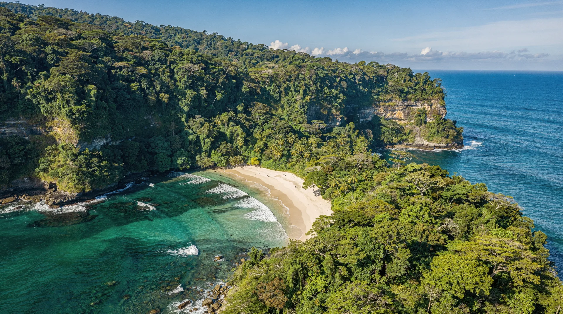
Manuel Antonio and Quepos
Manuel Antonio is Costa Rica’s most visited national park — a tiny but extraordinarily wildlife-rich peninsula of white-sand beaches and tropical forest, 3 hours south of San José via Quepos. The park is closed on Tuesdays and requires a timed reservation in advance (capacity is limited). Morning guided tours are the most reliable way to see sloths (three-toed and two-toed), squirrel monkeys, and white-faced capuchins in the canopy.
Quepos is the service town adjacent to the park — a working fishing port with good restaurants, a marina, and shuttle connections to/from San José. Manuel Antonio NP: guided tour with entrance fee included — from $60 is the most highly rated guided park tour, including entrance fees. For a water-based alternative, Manuel Antonio catamaran cruises are spectacular — Manuel Antonio: catamaran cruise with a meal — from $110 is the most popular operator.
Uvita and the Marino Ballena corridor
Uvita is where Costa Rica’s most extraordinary marine wildlife experience occurs: humpback whale watching in Marino Ballena National Park. Two distinct populations of humpback whales use the Gulf of Dulce waters — southern hemisphere whales from August through October, northern hemisphere whales from December through April. The park protects the famous whale-tail rock formation at low tide, visible from the air and from the beach.
Marino Ballena: whale watching in Uvita — from $80 is the most booked whale-watching tour from Uvita, running in the mornings when ocean conditions are calmest. For snorkelling at Caño Island Biological Reserve — arguably the best marine snorkelling in Pacific Costa Rica — day trips run from Uvita in around 2 hours by boat.
The Osa Peninsula and Corcovado
The Osa Peninsula, in the far south of the province, is the most biodiverse place on Earth per square kilometre according to National Geographic — a bold claim, but one that field biologists find difficult to dispute. Corcovado National Park protects most of the peninsula’s primary rainforest; it is home to all four Costa Rican monkey species, tapirs, all six cat species (including jaguar), harpy eagles, and scarlet macaws in concentrations no longer found elsewhere in Central America.
Visiting Corcovado requires hiring a certified guide (mandatory by law), booking a ranger station entry in advance (Sirena Station is sometimes closed September through November for renovation or weather damage), and budgeting physically for full-day hikes in heat and humidity. Drake Bay: Corcovado NP and Sirena Station tour — from $135 runs guided day trips from Drake Bay, the most accessible access point.
Santa Teresa and the Nicoya coast
Santa Teresa and its twin village Mal País occupy the southern tip of the Nicoya Peninsula — an area of internationally known surf breaks, luxury yoga retreats, and carefully managed boutique hotels. Getting here requires crossing the Gulf of Nicoya by ferry (Puntarenas to Paquera, 1.5 hours) then driving south, or taking a Sansa flight to Tambor.
The area around Cabo Blanco Nature Reserve — Costa Rica’s first protected area, established in 1963 — is covered in the dedicated Cabo Blanco–Mal País guide.
Getting around Puntarenas province
The Costanera Sur highway (Route 34) along the Pacific coast is the backbone of Puntarenas travel — well-paved from Jacó to Uvita, and in improving condition toward Palmar Norte. South of Palmar Norte toward Puerto Jiménez and Drake Bay, roads become rougher; the Drake Bay road requires a 4WD in rainy season.
Sansa domestic flights connect San José to Drake Bay (25 minutes), Puerto Jiménez (40 minutes), and Tambor (near Santa Teresa, 20 minutes) — indispensable for reaching the most remote south. Shuttle services connect San José to Jacó ($35, 1.5 hours), Quepos ($50, 3 hours), and Monteverde ($35, 4 hours by shuttle including the ferry).
Frequently asked questions about Puntarenas province
Is Puntarenas city worth a stop?
Puntarenas city — the provincial capital — is a hot, dusty port town on a narrow peninsula extending into the Gulf. It is primarily a transit point for the ferry to Paquera (for Nicoya Peninsula) or the Tortuga Island day trips. Few travellers stay overnight; there are better base options further along the coast.
How do I get to Monteverde from Manuel Antonio or Jacó?
There is no quick way. The most common route: Jacó or Manuel Antonio → San José → Monteverde (total 4-5 hours). Some travellers use the Pacific coastal road north to Puntarenas, then take a jeep-boat-jeep combination through Arenal — a scenic but long route. Budget a full day for any cross-province transfer. Shuttle companies (Interbus, GrayLine) cover most combinations with seat reservations.
What is the best time to see whale watching in Uvita?
August through October is the peak for southern hemisphere humpback whales — mothers with calves are common, and population density is highest. December through March brings northern hemisphere humpbacks. Whale watching is less certain in November and April-July, though dolphin encounters (bottlenose, spinner) are reliable year-round.
Is Corcovado worth the effort for a casual traveller?
If you are comfortable with a full day of hiking in heat and humidity, a very early start, and some physical challenge — yes, unreservedly. The wildlife density in Corcovado is unlike anywhere else in Costa Rica. If you prefer a more managed experience with guaranteed sloth sightings and short walks, Manuel Antonio is the better fit. Corcovado rewards those who come prepared.
Where to go next
Puntarenas province connects south toward Panama via the Paso Canoas border crossing, north toward Guanacaste province along the Nicoya coast, and east toward San José province via the Costanera and Cañas routes. Heading by sea, Caño Island and Cocos Island are the premier diving destinations accessible from this province.