Costa Rica microclimates explained: why weather differs by region
Why does weather differ so dramatically between Costa Rica regions?
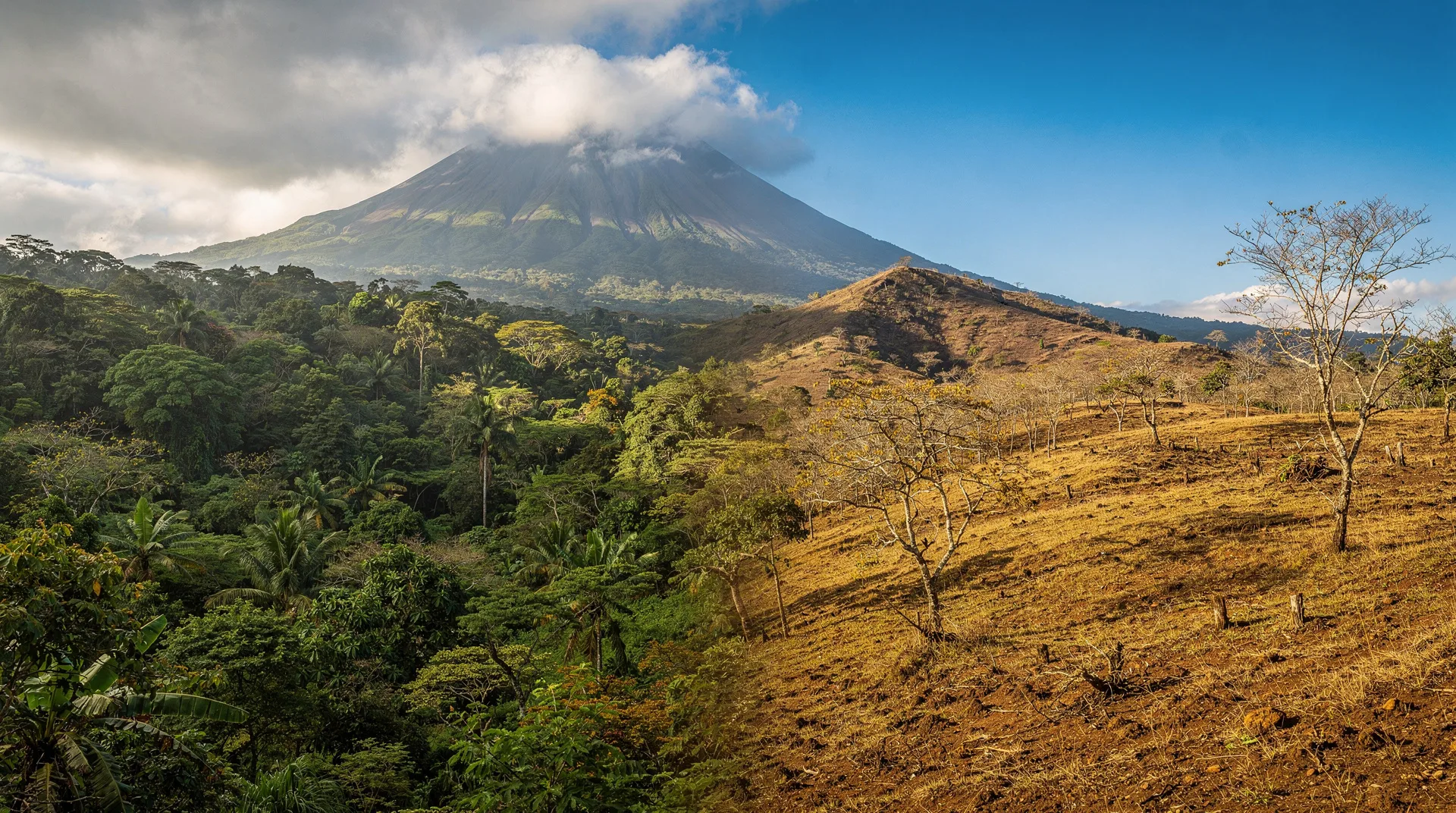
Costa Rica sits on the Continental Divide of the Americas with mountains reaching 3,800m. The Pacific watershed faces prevailing northeasterly trade winds differently than the Atlantic (Caribbean) watershed. Add altitude bands from 0m sea level to 3,821m at Chirripó and you get 12 distinct climate zones in a country smaller than West Virginia — explaining why Guanacaste can be bone dry while Tortuguero receives 7,000mm of annual rainfall.
Why the same day can mean sunshine and thunderstorm at once
One of Costa Rica’s most disorienting surprises for first-time visitors: you can check the weather forecast for Tamarindo (sunny, 34°C) and for Tortuguero (heavy rain, 27°C) on the same day in January. Two places in the same country, roughly 350 km apart, experiencing conditions that are climatically worlds apart.
This is not a failure of forecasting. It is the fundamental nature of Costa Rica’s geography. The country sits on the Continental Divide of the Americas, straddling two ocean influences, with mountain ranges rising to nearly 4,000 metres and an extraordinary diversity of altitude, aspect, and proximity to oceanic moisture sources. The result is a country that the World Meteorological Organization classifies as having 12 distinct climate zones — all within a territory about the size of West Virginia.
Understanding these microclimates is not academic. It changes which month you visit, which region you prioritise, and what clothes you pack. This is the guide that explains how it all works.
The two watersheds: the most important concept
The single most important thing to understand about Costa Rica’s climate system is the continental divide and the two watersheds it creates.
The Pacific watershed faces south and west, receiving moisture primarily from the Pacific Ocean and the southwesterly moisture flows during green season. The seasonal pattern here is well-defined: a distinct dry season (December-April) and a green season (May-November).
The Atlantic (Caribbean) watershed faces north and east, receiving constant moisture from the Caribbean Sea via the northeast trade winds. This side of the country has no true dry season — it rains year-round — but it does have a relative dry window in September-October when the trade winds shift direction.
The Continental Divide runs through the centre of the country via the Tilarán range, the Central Volcanic Cordillera (Poás, Barva, Irazú), and the Talamanca Cordillera (Chirripó). Moisture-laden air from the Caribbean hits these mountains, rises, cools, and drops its rain on the Caribbean slope. The air that crosses the divide to the Pacific side has already lost most of its moisture — which is part of why the Pacific lowlands have a defined dry season at all.
Climate zone 1: Guanacaste Pacific dry forest (0-300m)
The northernmost Pacific region — the Guanacaste province covering Tamarindo, Liberia, Playa Conchal, Nosara, Sámara, and the Papagayo peninsula — has the most extreme dry season in Costa Rica.
Annual rainfall in parts of Guanacaste drops to 700-1,200 mm, concentrated almost entirely in the May-November green season. December through April is genuinely arid. The vegetation is tropical dry forest — deciduous trees that lose their leaves in the dry season, which is why Guanacaste looks brown in January-March and green in August-October. This is the opposite of what most people expect from “tropical” — the “dry” season gives you a drier, Savannah-like landscape.
The Papagayo winds are a Guanacaste-specific phenomenon. From December through March, strong northerly winds flow down from Central America, accelerating through the Gulf of Papagayo due to the gap in the mountains. Wind speeds can reach 50-60 km/h on exposed beaches, creating choppy conditions for boats but spectacular conditions for kitesurfing at Playa Copal and Isla de Chira. Sheltered bays like Playa Hermosa and Potrero are calmer even when the Papagayo is blowing.
Temperature range: 28-38°C year-round at the coast; March-April peaks are extreme.
Rincón de la Vieja NP: Las Pailas trail — from $90Climate zone 2: central Pacific (Jacó to Quepos, 0-200m)
The Central Pacific — Jacó, Quepos, Manuel Antonio — receives more rainfall than Guanacaste but still follows the clear Pacific seasonal pattern. Annual rainfall in Manuel Antonio is around 3,000-3,500 mm, mostly falling May-November.
The key difference from Guanacaste is the forest type. Manuel Antonio and Jacó sit in transitional forest that stays greener even in dry season, because the mountains behind them capture some Caribbean moisture and channel it via rivers. The landscape never fully desiccates the way Guanacaste does.
This zone is also slightly more protected from the Papagayo winds, though northerlies can still make the Pacific choppy in February-March.
Climate zone 3: southern Pacific (Uvita, Osa Peninsula, Drake Bay, 0-500m)
The southern Pacific is one of the wettest areas in Costa Rica, receiving 4,000-6,000 mm of annual rainfall. The Osa Peninsula and Drake Bay area sit at the foot of the Talamanca Cordillera, which traps enormous amounts of moisture from both Pacific and Caribbean systems.
Even in dry season (December-April), the southern Pacific receives occasional rain. This is why Corcovado National Park is rainforest — not dry forest — despite being on the Pacific side. The difference in rainfall between Guanacaste (700 mm/year) and Drake Bay (5,500 mm/year) is one of the most extreme within-country contrasts in all of Central America.
The practical implication: the Osa Peninsula has no truly dry month — January and February are the driest, but you should still expect occasional rain and dirt roads that retain moisture. Heavy 4WD is advisable year-round.
Wildlife density in the southern Pacific is related directly to this rainfall pattern. The Osa Peninsula’s extraordinary biodiversity — including all four Costa Rican monkey species, tapirs, jaguars, harpy eagles — exists because the reliable moisture sustains the most complex rainforest ecosystem in Central America north of the Amazon.
Climate zone 4: the Central Valley (San José, Cartago, Heredia, Alajuela, 900-1,500m)
The Central Valley sits at 1,100-1,500 metres altitude on a high plateau between the Caribbean-facing and Pacific-facing slopes. This altitude creates a temperate climate that bears little resemblance to the coastal zones:
- Year-round temperatures: 18-26°C, rarely exceeding 28°C or dropping below 14°C at valley floor
- Dry season (Dec-Apr): Clear mornings, low humidity, cool nights
- Green season (May-Nov): Sunny mornings, afternoon thunderstorms, cool nights
San José, Heredia, and Alajuela are comfortable year-round by tropical standards. The altitude is why Costa Rica has one of the lowest rates of heat-related illness of any tropical country — most of the population lives above 1,000 metres.
The volcanoes above the Central Valley (Poás at 2,700m, Irazú at 3,432m, Barva at 2,906m) create their own micro-zones: typically cooler, cloudier, and wetter than the valley floor. Irazú is famously cold and windy at the crater, requiring a jacket even in February.
Climate zone 5: Monteverde and the Tilarán cloud forest (1,200-1,800m)
Monteverde and the continental divide zone around Santa Elena represents one of the most distinctive microclimates in Costa Rica. Moisture-laden Caribbean trade winds hit the Tilarán Cordillera and are forced upward, where they cool and condense into the permanent mist and cloud that give cloud forests their name.
Annual rainfall at Monteverde is approximately 3,000 mm, but what makes the climate here unique is the constant horizontal precipitation — water condensing directly from mist onto leaves and dripping off the forest. This moisture input is additional to vertical rainfall and explains why the cloud forest receives more effective water than rain gauges record.
For visitors, the cloud forest experience depends on accepting mist as a feature, not a bug. The famous visibility — or lack of it — in Monteverde’s forest is exactly what sustains the density of mosses, orchids, bromeliads, and epiphytes that cover every surface. The forest looks the way it does because of the mist.
Quetzal sightings at Monteverde peak in March-May during the dry season transition, when the birds move between altitude bands following fruiting avocado trees. See our quetzal watching guide for timing.
Monteverde and Santa Elena: cloud forest bird-watching tour — from $65Climate zone 6: the Caribbean lowlands (Tortuguero, Cahuita, Puerto Viejo, 0-200m)
The Caribbean coast has the most dramatically different climate from the Pacific, and it is the source of most visitor confusion.
Key facts about the Caribbean climate:
- No true dry season: Rain falls year-round, with annual totals reaching 3,000-5,000 mm
- Relative dry windows: September-October and February-March see significantly reduced rainfall
- Opposite of Pacific: When Guanacaste is in peak dry season (January), the northern Caribbean (Tortuguero) is often wetter
- Trade wind influence: Northeast trade winds from the Caribbean Sea deliver constant moisture to the coast year-round
Tortuguero, at the northern end of the Caribbean coast, receives approximately 5,000-7,000 mm of annual rainfall — making it one of the wettest places in Costa Rica. The canals of Tortuguero function year-round because the surrounding rainforest’s rainfall regime never stops.
Puerto Viejo and Cahuita in the southern Caribbean have a slightly different pattern. The Talamanca mountains provide some shelter from certain rain systems, and the September-October dry window is more pronounced here than in Tortuguero. October in Puerto Viejo is genuinely sunny and beautiful — perhaps the Caribbean’s best month.
The practical consequence of this pattern: if your itinerary mixes Caribbean coast with Pacific coast, the best timing depends on which coast you prioritise. A September trip that does Tortuguero (turtle peak, green season on the canals) and Puerto Viejo (relative dry window) is a stronger Caribbean itinerary than January, even though January is excellent on the Pacific.
Climate zone 7: the Talamanca highlands (San Gerardo de Dota, Chirripó, 1,800-3,821m)
The Talamanca Cordillera in the south-centre of Costa Rica contains Costa Rica’s highest point, Cerro Chirripó at 3,821m, and the cloud forest valley of San Gerardo de Dota at approximately 2,200m. This altitude band creates a climate that surprises visitors who associate Costa Rica exclusively with tropical warmth.
At San Gerardo de Dota, daily temperatures range from 5-18°C year-round. Nights regularly drop below 10°C. The area receives abundant rainfall from both Caribbean and Pacific weather systems, and the high humidity sustains the cloud forest that provides habitat for the resplendent quetzal.
Cerro Chirripó’s summit experiences temperatures that drop to -5°C at night, and snow or ice crystals are possible at the summit in the January-March dry season when clear skies allow maximum radiative cooling. Hikers attempting Chirripó need clothing appropriate for near-freezing temperatures regardless of what month they visit.
The Talamanca highlands are one of the only places in Costa Rica where altitude alone, rather than season, is the dominant climate determinant. See our hiking Cerro Chirripó guide for what to expect.
How to read a microclimate forecast for your trip
When planning a Costa Rica trip, checking a single national weather forecast is misleading. The correct approach:
-
Find your specific destination’s forecast: Use the Costa Rican national weather service (IMN — Instituto Meteorológico Nacional) or reliable international services like Weather.com filtered to your specific town, not “Costa Rica.”
-
Know which watershed your destination is on: Pacific destinations follow the standard dry/green season pattern. Caribbean destinations do not.
-
Altitude first: If visiting Monteverde, La Fortuna highlands, San Gerardo de Dota, or Chirripó, check the altitude-specific forecast — it will be dramatically different from the lowland forecast.
-
Morning/afternoon split: For any Pacific or Central Valley destination in green season, the morning forecast is more relevant for activity planning than the afternoon forecast.
-
Use the IMN sea breeze timing: IMN (imn.ac.cr) publishes seasonal forecasts and rainfall averages that give you realistic expectations for monthly conditions at each destination.
Microclimates and wildlife distribution
The direct link between microclimates and wildlife is one of Costa Rica’s most fascinating dynamics. Different climate zones support different ecosystems:
- Guanacaste dry forest: Dry-forest specialist species — white-tailed deer, coatimundis, dry-forest birds (magpie jays, Turquoise-browed motmots), and iguanas
- Central Pacific transitional forest: High mammal diversity including all four monkey species at Carara and Manuel Antonio
- Southern Pacific/Osa rainforest: The highest biodiversity — tapirs, jaguars, harpy eagles, Baird’s tapirs — sustained by the constant rainfall
- Caribbean lowlands: Different species assemblage — great green macaws (threatened), Caribbean slope birds, caiman, river turtles
- Cloud forest: Resplendent quetzals, three-wattled bellbirds, cloud forest salamanders, and an extraordinary density of orchid and bromeliad species
This is why wildlife specialists often plan their Costa Rica itineraries around climate zones rather than around destinations — the ecosystem is the attraction, and the ecosystem is driven by rainfall and altitude.
For a practical guide to matching your trip timing with specific ecosystems, see our bird watching by region guide and wildlife watching ethics guide.
Applying microclimate knowledge to your itinerary
Understanding Costa Rica’s climate zones translates directly into better trip planning:
If you want guaranteed beach sun: Focus on Guanacaste or the Central Pacific during December-April. Guanacaste’s north (Tamarindo, Liberia, Papagayo, Conchal) is the driest and most reliable zone in the entire country during dry season.
If you want wildlife events (turtles, whales): Build your itinerary around green season months when most of these events peak — but pair Pacific coast destinations with the weather-flexible mindset those months require.
If you want both beach and wildlife: Consider a split itinerary — Pacific coast beach in the first half, Caribbean coast in September-October (when it is dry and wildlife is active). The 2-weeks complete Caribbean Pacific volcanoes itinerary does exactly this.
If you want the most comfortable year-round climate: Base yourself in or near San José (Central Valley) at 1,100-1,500m altitude. This gives you 20-25°C temperatures year-round with manageable green season rain and excellent day-trip access to both coastal zones and the highlands.
If you are sensitive to altitude: Avoid committing to extended highland stays without acclimatisation time. The transition from sea level to 2,000+ metres at San Gerardo de Dota or the Chirripó approach can cause mild altitude headaches for some visitors. Spend a night at 1,200m (San José) before going higher.
The best time to visit Costa Rica guide integrates these microclimate patterns with the month-by-month pricing and wildlife calendar to help you build the most rewarding itinerary for your priorities.
Frequently asked questions about Costa Rica microclimates
Can it be raining in Manuel Antonio while it’s sunny in Guanacaste?
Yes, frequently. In January during peak dry season, Guanacaste often experiences rain-free days while Manuel Antonio may see a brief afternoon shower. The gap between the two is even more dramatic in October when Guanacaste (southern) is at its wettest and the Caribbean around Cahuita is at its sunniest.
Why does Monteverde seem to be cloudy even in dry season?
Monteverde sits directly in the path of northeast trade winds that carry Caribbean moisture over the Continental Divide. This horizontal moisture input continues regardless of the Pacific seasonal pattern. The cloud forest is named for this permanent cloud — it is not a weather anomaly but the defining characteristic of the ecosystem. If you visit Monteverde hoping for clear vistas, early morning is your best chance before the trade winds strengthen.
What is the driest place in Costa Rica?
The Guanacaste interior around the Nicoya Gulf and Santa Cruz receives as little as 700-900 mm of annual rainfall — comparable to parts of southern Spain. This is the heart of the tropical dry forest biome, the most endangered tropical forest type in the Americas.
What is the wettest place in Costa Rica?
The Caribbean slopes of the Talamanca Cordillera and the northern Caribbean lowland around Tortuguero and Barra del Colorado receive 6,000-7,000 mm annually. Some highland valleys on the Caribbean slope receive even more. By comparison, London receives about 600 mm per year.
Does the rainy pattern shift with climate change?
Yes, and measurably. The IMN has documented changes to the timing of the dry-to-green season transition, longer dry season droughts in Guanacaste, and more intense rainfall events during green season. The veranillo (July mini-dry-spell) is also showing more variability than historically observed. For a country that depends on predictable rainfall for both agriculture and tourism infrastructure, these shifts represent a serious planning challenge in the coming decades.
Is there a part of Costa Rica with consistently good weather year-round?
The Central Valley (San José, Heredia, Cartago) at 1,100-1,500 metres is the most consistently temperate zone — never too hot, never too cold, and with a green season that is manageable rather than extreme. Many residents consider it the most liveable climate in the country. For visitors, it lacks beach access but is an excellent base for day trips to volcanoes, coffee plantations, and wildlife reserves.