Road conditions in Costa Rica by region and season
Which are the worst roads in Costa Rica?
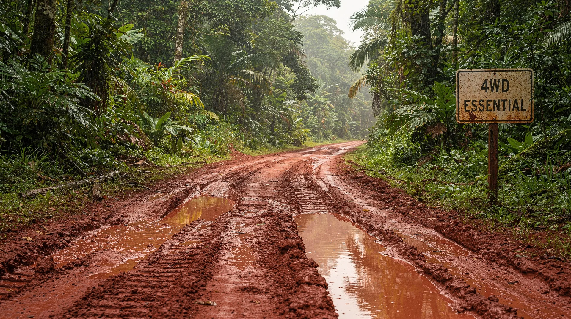
Monteverde's 35 km gravel approach, the Drake Bay/Sierpe access, and the Osa Peninsula dirt tracks. Caribbean coastal roads flood seasonally. All require 4WD.
Understanding Costa Rica’s road tiers
Costa Rica’s road network divides into three practical tiers, and knowing which tier you are on at any given moment is the difference between a comfortable drive and an hours-long ordeal.
Tier 1 — Main national highways. These include Ruta 1 (Pan-American), Ruta 27 (Pacific motorway), and Ruta 32 (Atlantic Highway). Paved, maintained, and generally in good condition year-round. These connect San José to Liberia, the Pacific coast, and Limón. Standard 2WD is perfectly adequate.
Tier 2 — Paved secondary roads. Ruta 21 (Guanacaste coastal), Ruta 4/141 (San José to La Fortuna), Ruta 34 (Pacific coastal south of Jacó). Paved but with more potholes, narrower lanes, and occasional flooding during heavy rain. 2WD is fine in dry season; higher clearance is useful in wet season.
Tier 3 — Unpaved tertiary roads. Everything else: the Monteverde approach, Osa Peninsula tracks, Drake Bay access, much of the rural Caribbean. 4WD is effectively mandatory for most of this tier, particularly in the rainy season (May–November).
This guide works through the specific conditions in each major tourist region, with detail on which stretches cause the most problems and when.
Central Valley and main highways (year-round excellent)
The paved highway network in and around San José — Ruta 1, Ruta 2, Ruta 27, Ruta 32 — is the best-maintained in the country. These roads are engineered to international standards, have working drainage, and receive regular maintenance. You will encounter potholes and occasional surface degradation even here, but nothing that requires anything beyond a standard vehicle.
Traffic, not road conditions, is the challenge in the Central Valley. San José’s morning rush hour (7–9am) and afternoon rush (4–7pm) can double or triple travel times on urban sections. Ruta 27’s toll motorway is significantly better than the older Ruta 3 (Costanera) for reaching the Pacific and avoids the worst urban congestion.
The approach roads to the Central Valley volcanoes — Poás, Irazú, Barva — are all paved but narrow and steep. The access road to Volcán Poás is paved to the park gate. Irazú’s access road from Cartago is similarly paved. Both are fine in standard vehicles but require slower speeds around hairpin bends.
Monteverde and the cloud forest zone
The main Monteverde road (critical information)
The road from the Pan-American Highway to Monteverde (Santa Elena) is the most famous driving challenge in Costa Rica tourism, and for good reason. Two main approaches exist:
Via Las Juntas (Ruta 606 from Cañas): Approximately 35 km unpaved from the highway to Santa Elena. This is the shortest route but also the roughest. The surface varies from packed gravel to loose rock to deeply rutted dirt depending on rainfall and recent maintenance. Expect: maximum speeds of 20–30 km/h for extended stretches, significant vibration, some blind corners, and passing sections that require one vehicle to reverse.
Via Sardinal / Quebrada Grande (from Río Lagarto): Approximately 40 km but with a longer paved section before the unpaved portion begins. Marginally better surface but not dramatically so.
The Tilarán route (Ruta 145): A longer but entirely paved alternative that loops north via Tilarán. Total time from the Pan-American is approximately 4 hours versus 1.5 hours on the direct unpaved route. If your rental agency’s insurance does not cover unpaved roads, this is the only compliant option.
Rainy season condition (May–November): The unpaved approach sections become significantly more challenging. Deep mud in low sections, reduced visibility from cloud cover, and occasional landslide debris across the road. A high-clearance 4WD is essential; ground clearance is more important than four-wheel traction on this specific road.
Dry season condition (December–April): Still unpaved and rough, but manageable in a capable 4WD without the mud factor. Dust replaces mud as the annoyance.
Getting to Monteverde by shuttle
For travellers unwilling or unable to drive the Monteverde road, the shuttle services overview covers the Interbus and GrayLine options, both of which use the same unpaved road but with experienced drivers. The lake crossing shuttle from La Fortuna is a popular alternative — boat across Laguna de Arenal, then shuttle to Monteverde — that avoids the worst road sections and reduces total travel time to approximately 3 hours from La Fortuna.
Guanacaste coast (dry season excellent, isolated issues in wet)
The main Guanacaste coastal highway (Ruta 21 from Liberia) is paved and well-maintained. Tamarindo, Playa Flamingo, Playas del Coco, and Playa Hermosa are all reached on paved roads. The road from Liberia airport (LIR) to Tamarindo is approximately 1 hour and 70 km — straightforward in any vehicle.
Exceptions:
Las Catalinas and Potrero area: The road from Brasilito to Las Catalinas uses a short unpaved stretch that becomes deeply rutted during heavy rain. A high-clearance vehicle or 4WD is helpful.
Rincón de la Vieja approach: The main road to Hacienda Guachipelín and the national park entrance (from Liberia via Curubandé) is partially unpaved. The 18 km from the highway to the park gate includes approximately 8 km of gravel. Manageable in a capable 2WD in dry season; better with 4WD in wet season.
Nosara from Nicoya: The road from Nicoya to Nosara (approximately 55 km) is partially unpaved and notorious for its condition during rainy season. The unpaved sections south of Garza are the worst. A 4WD is recommended year-round, mandatory in the wet season. This is one of the roads where the condition varies most dramatically by recent rainfall — checking Waze before departure is essential.
Sámara: Better-maintained access than Nosara. The road from Nicoya to Sámara (approximately 40 km) is mostly paved with manageable unpaved sections near the beach.
La Fortuna and the Arenal area (mostly good)
The main access to La Fortuna from San José via Ruta 4 (Ciudad Quesada) is entirely paved and in good condition. From Liberia via Cañas, the Pan-American Highway connects well to the La Fortuna junction — also paved.
Within the Arenal area:
The road around the south shore of Laguna de Arenal (from La Fortuna to Nuevo Arenal and then Tilarán) is paved but narrow, with significant winding and some sections that deteriorate after heavy rain. Perfectly driveable in 2WD at reduced speed.
The road to Caño Negro from La Fortuna (Ruta 4 north via Upala) is largely paved to Caño Negro itself. The final stretch approaching the wetland reserve involves some unpaved road. 4WD recommended but not always required in dry season.
Río Celeste / Tenorio National Park: The access road from the Pan-American Highway (near Bijagua) is paved to the park gate. No 4WD required. The area north of Arenal toward Bijagua has excellent paved roads.
Drake Bay and the Osa Peninsula (most challenging region)
This is where Costa Rica’s road conditions become genuinely serious. The Osa Peninsula has some of the worst tertiary roads in the country, and driving here without preparation and the right vehicle is a poor decision.
Drake Bay access
Getting to Drake Bay by land requires:
- Driving from San José to Palmar Norte (approximately 4 hours on paved road, mostly Ruta 27 + Ruta 34).
- From Palmar Norte to Rincón via Ruta 245 — a partially unpaved road that crosses several river fords.
- From Rincón to Drake Bay — approximately 25 km of deeply rutted dirt road with multiple river crossings. One of these crossings (the Río Drake mouth) may be tidal and impassable at high tide or during heavy rain.
The Río Sierpe alternative: Most visitors to Drake Bay use the boat from Sierpe (Rincón de la Vieja) rather than driving the final section. Sierpe is reached on paved Ruta 18 from Palmar Norte (approximately 20 minutes). From Sierpe, river and ocean boat to Drake Bay takes approximately 1 hour. This eliminates the worst road section.
Flying is the most practical option: Sansa flies San José to Drake Bay in approximately 50 minutes. For most itineraries, this is the right choice. See the internal flights guide for details.
Puerto Jiménez and road access
The road from Palmar Norte to Puerto Jiménez (Ruta 245) is paved for most of its length, with deteriorating sections toward Puerto Jiménez. In dry season, this is manageable in a capable 2WD with good clearance. In rainy season (particularly September–November), flooding and road surface collapse is common.
The road from Puerto Jiménez into the Corcovado zone (toward Carate) is unpaved and very rough. 4WD mandatory, and conditions can make this road impassable for days after heavy rain. Always check conditions locally before attempting it.
Seasonal closure: During September–November, the Corcovado Sirena Station is sometimes closed due to erosion and road access issues. Plan accordingly if visiting Osa Peninsula in the shoulder wet season.
Caribbean coast (mixed conditions, seasonal flooding)
San José to Limón (Ruta 32)
The Atlantic Highway from San José to Limón is the best-maintained Caribbean route: four lanes, paved, and generally in good condition. The 160 km drive takes approximately 2.5 hours without stops.
However: the Río Reventazón canyon section (near Angostura) is subject to landslides during heavy rain and has been closed seasonally in recent years. Always check Waze or Costa Rica’s road authority (MOPT, at mopt.go.cr) before travelling this route during sustained heavy rain.
Limón to Puerto Viejo (Ruta 36)
From Limón south to Puerto Viejo and Manzanillo, Ruta 36 is paved. Condition is mixed — the road authority maintains it, but funding is inconsistent and potholes are common. The drive from Limón to Puerto Viejo takes approximately 45 minutes. 2WD is adequate.
The 13 km road from Puerto Viejo to Manzanillo (paved) passes through Cahuita and continues to the end of the paved network. The Puerto Viejo destination guide covers this specific section well.
Caribbean back roads (variable, seasonal flooding)
Back roads in the Talamanca indigenous territory, around Bribrí, and toward the Panama border area (Sixaola) are partially unpaved. The Sixaola crossing itself is reached on paved Ruta 36 extending south from Manzanillo. High clearance is useful on some sections.
Flooding risk: The Caribbean coast receives more rainfall than the Pacific and flooding of low-lying roads is common during the wettest months (October–December). The road between Limón and Cahuita runs close to sea level in places and can flood briefly after very heavy rain.
Southern Pacific zone (challenging, worth knowing)
Uvita and the Costanera
The Costanera Sur (Ruta 34) running from Jacó to Dominical, Uvita, and Palmar Norte is paved throughout and is in relatively good condition. This is the main access road for the southern Pacific and does not require 4WD.
Dominical to Drake Bay: Once you leave the Costanera and head for Sierpe and beyond, road conditions degrade as described in the Osa section above.
Manuel Antonio area
The road from Quepos to Manuel Antonio (Ruta 235) is paved, approximately 7 km, and entirely manageable. The Manuel Antonio destination guide covers parking logistics inside the park zone.
The Savegre River valley road: If visiting Rafiki Safari Lodge or the Savegre area from Quepos, the road descends steeply into the valley on a partially unpaved track. 4WD recommended.
Seasonal summary: when roads are worst
| Region | Worst months | Main issue | Required vehicle |
|---|---|---|---|
| Monteverde approach | May–Oct | Deep mud, ruts | 4WD high clearance |
| Osa Peninsula (Corcovado zone) | Sep–Nov | Flooding, road collapse | 4WD, local advice essential |
| Drake Bay access road | Jun–Oct | River crossings impassable | 4WD or take boat from Sierpe |
| Nosara approach | May–Oct | Deep ruts, mud | 4WD |
| Ruta 32 (landslide zone) | Sep–Nov | Landslide risk | Check MOPT before travel |
| Caribbean back roads | Oct–Dec | Flooding | High clearance |
| Guanacaste main roads | Year-round excellent | Dust (dry) | 2WD sufficient |
| Central Valley highways | Year-round good | Traffic | 2WD sufficient |
Frequently asked questions about road conditions
Does road condition affect shuttle services?
Yes. Shared shuttles by Interbus, GrayLine, and Caribe Shuttle use the same roads, so delays from road conditions affect them too. Shuttle drivers are experienced with local conditions and know alternative routes, but significant road closures (landslide on Ruta 32, major flooding) affect all transport equally. The shuttle services overview covers what to expect from each operator.
Is there an official road condition service in Costa Rica?
MOPT (Ministerio de Obras Públicas y Transportes) maintains a website and Twitter feed with major road alerts. Waze’s Costa Rica community is often faster with real-time updates. Local Facebook groups (search “Costa Rica road conditions”) are actively updated by travellers and residents during storm events.
Can I drive to Monteverde in a standard 2WD rental car?
Technically yes, but most rental agencies’ insurance does not cover damage on unpaved roads classified as requiring 4WD, and the Monteverde approach falls into this category. If you have an incident, you will be liable. The practical advice: rent a 4WD for any itinerary that includes Monteverde. If you must use a 2WD, take the long paved route via Tilarán.
How do I know if a road is currently open or closed?
Check Waze before departing — closures from landslides or flooding appear quickly. Call your accommodation at the destination and ask them directly — they will know current conditions on their access road. For national parks, call SINAC or check the park’s Facebook page.
Are roads passable during the rainy season for the main tourist circuit?
Yes. The main circuit — San José, La Fortuna, Monteverde, Manuel Antonio — is fully accessible year-round. Rainy season adds difficulty only on unpaved secondary roads. With a 4WD and Waze, the standard circuit is manageable even in May–November. The best time to visit guide covers how weather affects the overall trip experience rather than just the roads.
Checking road conditions before you drive
Waze: The most reliable real-time source. Costa Rican drivers actively report landslides, flooding, and road closures. Download Waze before arriving and keep it running while driving.
MOPT (Ministerio de Obras Públicas y Transportes): Costa Rica’s road authority maintains a website (mopt.go.cr) with major route alerts. Updated during storm events.
WhatsApp groups: Many Osa Peninsula and remote area accommodations maintain guest WhatsApp groups where hosts share daily road condition updates. Ask your lodge to add you before departure.
Local radio: Radio Monumental and Radio Columbia broadcast road condition updates during major weather events. If you are staying somewhere with a local radio, ask your host to check if driving conditions are being discussed.
Your accommodation: The most direct option. Call or WhatsApp your next accommodation and ask: “¿Cómo está el camino hoy?” (How is the road today?). They will know and will tell you honestly.
Using transfers instead of driving
For the destinations with the most challenging road access — Drake Bay and Corcovado — the practical advice for most travellers is to avoid self-driving entirely. Private transfers from San José can handle the Sierpe-Drake Bay combination (road plus river boat), and Sansa flies to Drake Bay directly.
Costa Rica: private transportation service — from $220For travellers based in La Fortuna who want to reach Corcovado or the Osa, a combination of shuttle and domestic flight is almost always the better choice over driving the Osa roads in a rental car.
Related guides
The driving in Costa Rica guide covers the skills and techniques for the roads described here — river crossings, night driving, navigation setup. The rent a car or not guide helps you decide whether to drive at all given your specific itinerary. For the Osa Peninsula and Drake Bay specifically, the internal flights guide makes a compelling case for flying. The Drake Bay destination guide covers all access options with timing and cost.