Driving in Costa Rica: everything you need to know
Is driving difficult in Costa Rica?
Yes on rural roads — unmarked intersections, river crossings, and gravel tracks make navigation tricky. Waze and downloaded offline maps are essential. On main highways, driving is straightforward.
The honest picture of driving in Costa Rica
Costa Rica driving divides neatly into two very different experiences. On the main paved highways — Ruta 1 (the Pan-American heading northwest), Ruta 27 (the Pacific motorway from San José to Jacó), and Ruta 32 (the Atlantic Highway to Limón) — driving is entirely manageable for anyone accustomed to highways elsewhere in the Americas or Europe. Traffic is orderly, signage exists, and the roads are paved and maintained.
Off those main arteries, the situation changes significantly. Secondary and tertiary roads in Costa Rica are among the most demanding in Central America: unpaved gravel tracks that deteriorate in the rainy season, unmarked intersections where the only navigation option is local knowledge or GPS, river crossings without bridges that become impassable during heavy rain, and mountain roads without guardrails. Getting these roads wrong means a stuck vehicle, a broken suspension, or — at the extreme — a washed-out crossing that leaves you stranded for hours.
This guide covers both realities, with specific techniques for navigating each type of road successfully.
Navigation: Waze is not optional
Download before you leave
The single most important preparation for driving in Costa Rica is setting up your navigation before you leave the hotel in the morning. Do both of these:
Waze — Download the app and create an account before you arrive in Costa Rica. Waze is crowd-sourced and reflects real-time road conditions, including flooded sections, landslides, and police checkpoints. Costa Rican drivers use Waze extensively, which means the data quality is good even on secondary routes. The Costa Rica Waze community is active and updates conditions quickly during heavy rain events.
Google Maps offline download — In Google Maps, download the Costa Rica map region for offline use before you leave WiFi. This is your backup when you lose mobile signal, which happens frequently in mountain areas and the Osa Peninsula. Offline Google Maps won’t give live traffic data but will navigate you correctly on stored map data.
How Costa Rican addresses work
Road addresses in Costa Rica have historically been given by landmarks rather than by street numbers and names. “200 metres north of the Banco Nacional, then 50 metres east” is a genuine address format still used by many businesses and residences. Even GPS databases reflect this in places.
What this means practically: when you search for your destination in Waze or Google Maps, use the hotel or destination name rather than the street address. Most established accommodations and attractions are in the database. For remote lodges or private properties, the host should provide you with GPS coordinates — always ask for them before departure.
Road numbers and signage
Costa Rica’s national road network uses Ruta (route) numbers, but signage is inconsistent and often absent at key intersections. The roads you will use most:
- Ruta 1: Pan-American Highway. Runs north-south through the Central Valley and continues to Nicaragua. Paved, generally good condition.
- Ruta 27: The Via Interamericana. Connects San José to the Pacific coast via a toll motorway. Excellent condition. Toll booths approximately every 40 km — have USD or colones ready (approximately 600–900 CRC per toll, roughly $1–2).
- Ruta 32: Atlantic Highway from San José to Limón and the Caribbean coast. Good paved road, one of the most used.
- Ruta 4 / Ruta 141: San José to La Fortuna via Ciudad Quesada. Fully paved, some mountain sections with good views.
- Ruta 21: Guanacaste coastal highway. Paved, connects the main Guanacaste beach destinations.
- Ruta 606: The infamous Monteverde road. 35 km of unpaved gravel from the Pan-American to Santa Elena. See below.
The Monteverde road: what nobody tells you
The road from the Pan-American Highway (via the Sardinal or Las Juntas turnoffs) to Monteverde is the most discussed driving challenge in Costa Rica tourism. Here are the specific facts rather than the vague warnings.
Distance from Pan-American junction to Santa Elena: approximately 35 km.
Surface: Unpaved gravel and dirt. The section nearest the Pan-American has the roughest surface; conditions improve (slightly) closer to Santa Elena. The road has significant ruts, exposed rock sections, and narrow passing points.
4WD requirement: Rental agencies’ insurance policies typically do not cover damage sustained on the Monteverde road in a 2WD vehicle. In practice, many people drive it in 2WD during dry season without incident — but the insurance void means any incident is entirely your financial liability. In the rainy season (May–November), 4WD is genuinely necessary.
Time: Allow 1.5–2 hours for this 35 km section. The road demands slow, careful driving. Drivers who push the pace on the loose gravel face tyre blowouts and suspension damage.
Alternatives: The newer paved road from Sardinal (Ruta 145 via Tilarán) reaches Monteverde in about 4 hours from San José via a longer route that avoids the unpaved section. Ask your rental agency which road your insurance covers.
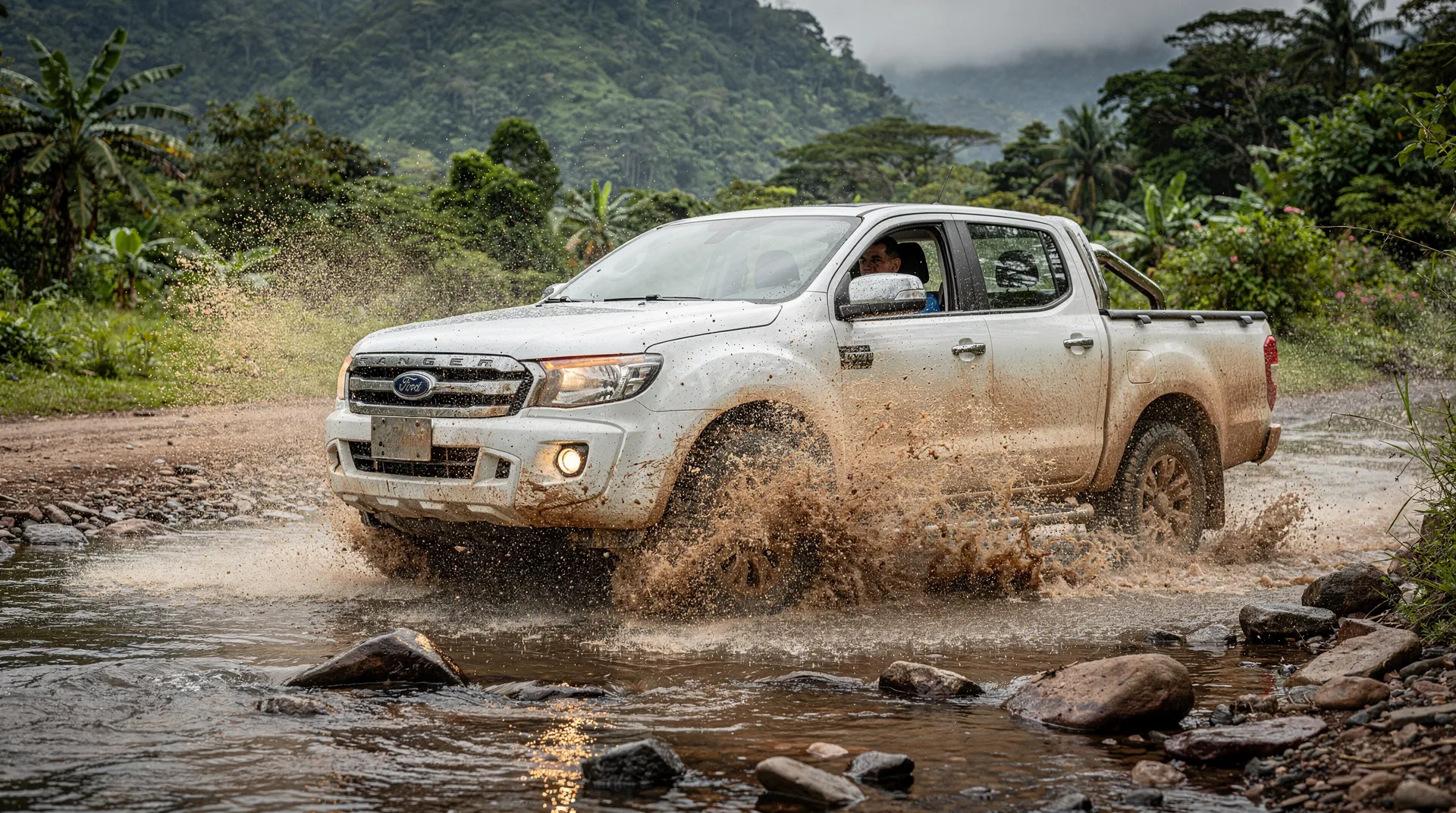
River crossings: how to handle them safely
In the rainy season and in remote areas of Costa Rica, you will encounter stream and river crossings without bridges. Drake Bay access, portions of the Osa Peninsula road system, and some Caribbean back roads all have these. The risk of misjudging a crossing is real — vehicles are swept off fords every season.
Rules for river crossings
Always stop and walk the crossing first. Before driving in, get out of the vehicle and walk the crossing on foot. You need to know: depth at the deepest point, current speed, and substrate (sandy and stable, or slippery rock). If the water is above your knees and moving fast, do not cross.
Enter slowly and in low range. Engage 4WD Low before entering. Drive slowly and steadily — do not stop mid-crossing and do not accelerate aggressively. A bow wave in front of the vehicle is your enemy; it can push water into the air intake.
Know your vehicle’s wade depth. Most 4WD SUVs have a wade depth of 50–60 cm (about knee height on an adult). Do not attempt crossings deeper than this.
Wait if in doubt. Rivers in Costa Rica can rise dramatically in 20–30 minutes during heavy rain. If a crossing looks marginal, wait. The water level may drop within an hour once upstream rain stops, or another local driver may arrive to lead the way.
Never cross at night. River conditions and depth are impossible to assess after dark. If a crossing is between you and your destination at night, find accommodation on your side and cross in the morning.
Driving rules and local habits
Legal basics
- Drive on the right, pass on the left.
- Speed limits: 100 km/h on highways, 80 km/h on secondary paved roads, 40–60 km/h in towns. Speed limits are enforced by radar, and fines are substantial (typically $150–300 for excessive speed violations).
- Seatbelts mandatory for all passengers.
- Mobile phones: using a handheld phone while driving is illegal. Use a dashboard mount.
- Children under 12 must use a car seat or booster. Some rental agencies provide these for $5–10 per day.
What local driving actually looks like
Costa Rican driving has specific patterns worth knowing. At unmarked intersections (common outside cities), the driver who arrives first has right of way in practice — but this is informally enforced. Hazard lights are used in Costa Rica to mean “thank you” after being let in, rather than an emergency signal as in the US — you may see this and initially be confused. Trucks and large vehicles regularly use the shoulder of the road to let faster traffic pass on narrow mountain roads — if a truck moves right and slows, they are inviting you to pass.
Night driving
Do not drive unfamiliar secondary roads after dark. The combination of unmarked potholes, livestock crossing roads with no lighting, and reduced visibility on unlit mountain curves creates genuinely elevated risk. On paved main highways (Ruta 1, Ruta 27, Ruta 32), night driving is safer but still not preferable. If your itinerary requires arriving at a destination after sunset, arrange accommodation partway and continue in the morning, or book a private transfer with a local driver.
Petrol stations and logistics
Distribution
Petrol stations (gasolineras) are well distributed along main highways and in larger towns. The gaps appear in remote areas: the Osa Peninsula (petrol is available in Puerto Jiménez but not many other points), the road to Drake Bay, and some Caribbean back roads. Always fill up when the tank is at half in remote areas.
Petrol types and prices
Costa Rica sells Regular (92 octane), Super (95 octane), and Diesel. Most rental 4WDs use Super. Prices are regulated by the government — as of early 2026, Super costs approximately 900–950 CRC per litre (roughly $1.70–1.85 USD). Diesel is slightly cheaper. Credit cards are accepted at most stations, though rural stations are cash-only — carry colones.
Paying tolls
The Ruta 27 Pacific motorway has multiple toll booths. You can pay in CRC or USD. Exact change is not required. If you have a FastPass transponder (rare for tourists but available), you can use the express lane. Otherwise, use the cash lanes — they are not long waits outside rush hour.
Parking and vehicle security
Theft from parked rental cars is the most common crime affecting tourists in Costa Rica. This is covered extensively in the safety in Costa Rica guide, but the core rule bears repeating: never leave anything visible in a parked vehicle.
Practical parking habits
Use attended car parks wherever possible. Manuel Antonio, the Arenal area, and Guanacaste beaches all have some attended lots. The fee ($2–5) is worth paying.
If parking unattended, empty the car. Move bags to the hotel before going to a beach or trail. If you cannot take the bag with you and must leave it in the vehicle, place it in the boot before you park — not visible, and positioned before anyone is watching.
Do not park at unofficial viewpoints. Random roadside viewpoints on scenic routes are known locations for smash-and-grab theft. If you want to stop for a view, choose a location with other tourists and open sightlines.
Costa Rica: private transportation service — from $220Driving from SJO: the first leg
The journey out of San José can be the most stressful part of a Costa Rica road trip for drivers unfamiliar with the city. Specific tips:
Avoid rush hour. San José traffic during 7–9am and 4–7pm is genuinely bad — the city’s infrastructure has not kept pace with growth. If you collect a rental car at SJO, either leave before 7am or wait until after 9am.
Use Waze from the first moment. The road numbering around San José is not intuitive, and one missed turn near the airport can add 20 minutes. Have Waze running before you leave the rental car lot.
The first motorway split. Leaving SJO toward the Pacific (Ruta 27), you will pass through a tunnel and several toll booths. The signs are there but the decision points arrive quickly. Waze handles this well — trust it over your intuition.
San José to La Fortuna: Take Ruta 1 north toward Ciudad Quesada, then follow signs toward La Fortuna. Total distance approximately 140 km, journey time 3–3.5 hours without stops.
San José to Manuel Antonio: Take Ruta 27 west toward Jacó, then follow Ruta 34 south. Total distance approximately 175 km, journey time 3–3.5 hours.
Frequently asked questions about driving in Costa Rica
Do I need an international driving licence?
No. Costa Rica accepts your home country driving licence for stays of up to 90 days. The licence must be in Roman script or accompanied by an official translation. US, EU, UK, Canadian, and Australian licences are all accepted without translation.
What happens if I drive through a flooded road and my car breaks down?
You are responsible for the damage. Most rental car CDW (Collision Damage Waiver) policies exclude flood damage, and driving through water that exceeds the vehicle’s wade depth is considered driver negligence. This is one reason to walk crossings before driving them.
Are there speed cameras in Costa Rica?
Yes. Speed cameras are deployed on Ruta 27 (the Pacific motorway) and are increasingly common on other main routes. Fines are applied to the rental company and passed to you as the registered driver. Speed cameras are not consistently signposted.
Can I park overnight at a national park trailhead?
This is not recommended. Trailhead parking areas at popular parks (Manuel Antonio, Rincón de la Vieja, Arenal) are unsupervised overnight and are targets for break-ins. Park your vehicle at your accommodation and take a day tour or shared transport to the park entrance. The Manuel Antonio National Park guide explains the logistics for that specific destination.
What is the fine for driving under the influence in Costa Rica?
Blood alcohol limits are 0.05% (stricter than the US but similar to most of Europe). Fines start at approximately $500 USD and licence revocation is possible. Random checkpoints (retenes) are common on popular tourist routes, particularly on weekend nights. Do not drive after consuming alcohol in Costa Rica.
How do I handle a police stop?
Pull over, turn off the engine, and stay in the vehicle. Officers will ask for your driver’s licence and the rental car documents (which should be in the vehicle). Be polite and cooperate. If you believe you are being asked to pay a bribe (unofficial payments are occasionally reported), say clearly that you prefer to pay any fine through official channels and ask for a written ticket (boleta). Note the officer’s badge number if something seems irregular.
Driving between the regions: a practical route guide
San José to La Fortuna
This is the most-driven tourist route in Costa Rica and one of the easiest. Take Ruta 1 north from San José toward Alajuela, then continue northwest on Ruta 141 via Ciudad Quesada (San Carlos) to La Fortuna. The road is paved throughout and in good condition. Driving time: 3–3.5 hours without stops. Watch for trucks on the mountain sections near Ciudad Quesada — passing opportunities are limited. Waze handles this route well.
La Fortuna to Monteverde
The lake crossing is faster than the road: take a boat across Laguna de Arenal (approximately 30 minutes), then shuttle to Monteverde (approximately 45 minutes). If you prefer to drive, the road via San Ramón is paved and takes approximately 4.5 hours. The short Jeep-Boat-Jeep is unique to Costa Rica — rental cars cannot be taken on the lake boat, so if you have a rental car you must drive the long road or leave the car in La Fortuna and rent a second one in Monteverde.
Monteverde to the coast
Descending from Monteverde toward the Pacific, the Pan-American Highway (Ruta 1) south leads to Jaco via Esparza (approximately 3 hours) or continues to Manuel Antonio (4 hours total from Monteverde). For Guanacaste beaches, head north on the Pan-American from the Monteverde junction, connecting to Ruta 21 near Cañas.
Pacific coast route (Ruta 34 Costanera)
The Costanera highway from Jacó south to Dominical, Uvita, and Palmar Norte is one of Costa Rica’s most scenic drives — the road follows the Pacific coast through jungle-covered hills with ocean glimpses. It is paved throughout and in good condition. This route connects the main southern Pacific destinations without requiring you to return to San José. Driving times: Jacó to Uvita approximately 2 hours; Uvita to Palmar Norte approximately 1.5 hours.
Related guides
The rent a car or not guide walks through whether a rental car is right for your specific itinerary before you commit to driving at all. For a destination-by-destination breakdown of which roads are most challenging and when, the road conditions by region guide provides specific seasonal detail. Travellers combining driving with ferry crossings should read the ferry routes guide for the Puntarenas-Paquera logistics. The shuttle services overview covers the no-driving alternative for the main tourist circuit.