Understanding Costa Rica's volcanic activity
How active is Costa Rica volcanically?
Six active, Ring of Fire position, OVSICORI monitors continuously.
Why Costa Rica is one of the world’s most volcanically active countries
Costa Rica is a small country — roughly the size of West Virginia — yet it hosts more than 60 volcanic features, of which six are classified as active by international standards. This extraordinary concentration is a direct consequence of the country’s position on the Pacific Ring of Fire, specifically at the convergence zone where the Cocos tectonic plate dives beneath the Caribbean plate in a process called subduction.
As the Cocos plate descends into the Earth’s mantle, it releases water and other volatiles that lower the melting point of the surrounding rock. The resulting magma rises through fissures and accumulates in subsurface chambers beneath Costa Rica’s mountain ranges. Over geological time — and continuing today — this has produced the Cordillera Volcánica Central (which contains Poás, Irazú, Turrialba, and Barva) and the Cordillera de Guanacaste (which contains Rincón de la Vieja, Miravalles, Tenorio, and Arenal, among others).
This is not a static system. The Cocos plate moves toward the Caribbean plate at approximately 80-90 mm per year — one of the fastest plate convergence rates in the world. That ongoing movement ensures that Costa Rica’s volcanic and seismic activity is persistent, not periodic. Minor earthquakes are felt somewhere in the country nearly every day. Volcanic monitoring is a national priority, not a scientific luxury.
OVSICORI: how Costa Rica monitors its volcanoes
The Observatorio Vulcanológico y Sismológico de Costa Rica (OVSICORI) is the national institution responsible for monitoring volcanic and seismic activity. Based at the Universidad Nacional in Heredia, it operates a network of seismometers, GPS stations, gas sensors, tiltmeters, and infrasound detectors deployed on and around the country’s active volcanoes.
OVSICORI’s monitoring system provides real-time data on:
- Seismic activity (earthquake frequency and magnitude beneath volcanoes)
- Ground deformation (GPS tracks millimetre-level swelling or deflation of volcanic edifices)
- Gas emissions (sulfur dioxide and carbon dioxide are key precursors to eruptive activity)
- Crater lake chemistry (hyperacidic lakes like Poás’s crater lake are sensitive indicators of subsurface activity)
OVSICORI publishes regular bulletins on its website (ovsicori.una.ac.cr) and issues alerts to the Comisión Nacional de Prevención de Riesgos y Atención de Emergencias (CNE) and the ICT (Costa Rican Tourism Board) when activity levels change. Park closures and access restrictions are implemented on OVSICORI’s recommendation.
For visitors, OVSICORI’s data is publicly accessible and updated regularly. If you are planning to visit a volcano and want to check current conditions, their bulletin page is the most authoritative source available — more reliable than tour operator websites or travel forums.
The six active volcanoes: current status
Costa Rica’s classification of “active” follows international convention: a volcano is considered active if it has erupted in the last 10,000 years and/or shows current signs of unrest (seismicity, gas emissions, deformation). By this standard, Costa Rica has six:
Arenal (1,670 m)
Last major eruptive phase: 1968-2010. Currently in a resting phase. Seismic activity continues at low levels; OVSICORI monitors but no precursors of renewed eruption are present as of 2026. The 1968 eruption killed 87 people and buried three villages — the most deadly volcanic event in modern Costa Rican history. See our dedicated Arenal guide for the full visitor context.
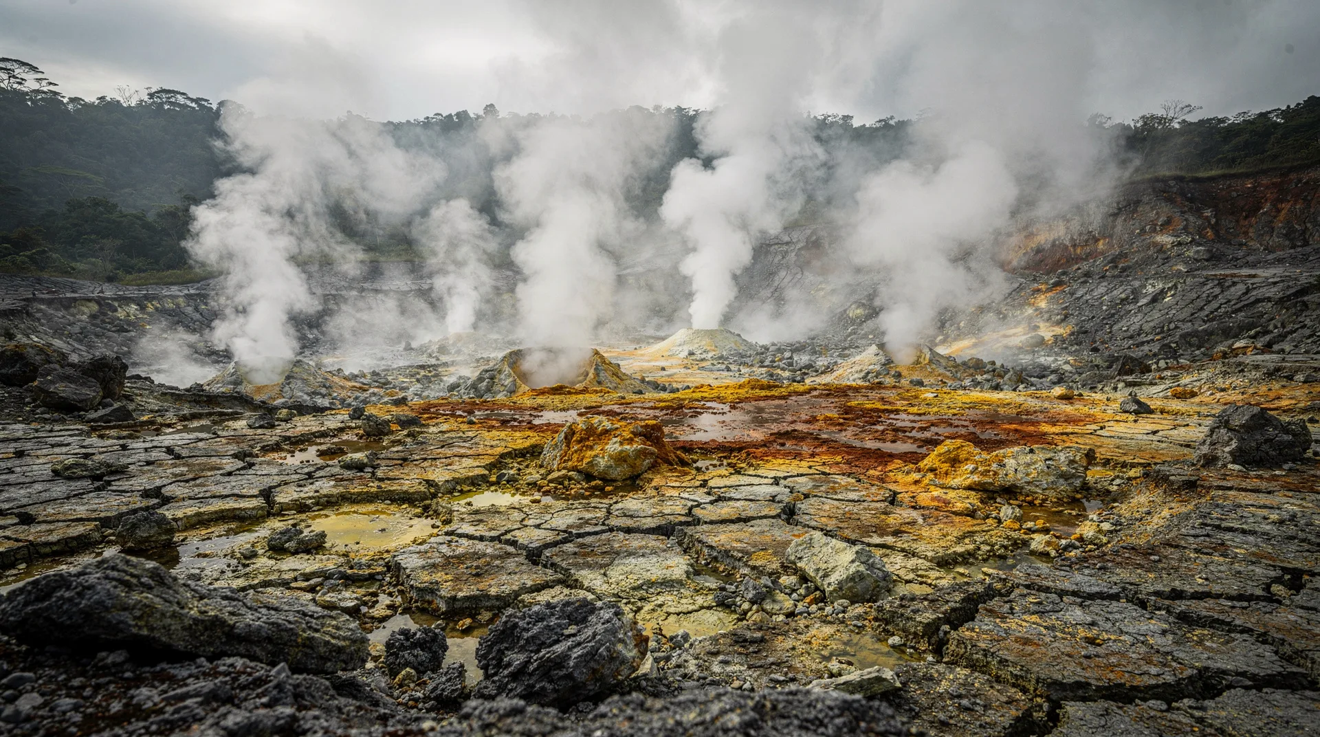
Poás (2,708 m)
One of the world’s most persistently active volcanoes. It has erupted frequently in historical time, including significant phreatomagmatic eruptions in 1989 and 2017. The 2017 eruption forced a prolonged park closure. The crater lake (Laguna Caliente) is among the most acidic natural bodies of water on earth — pH values of 0 or below have been recorded. Sulfuric acid concentration and lake temperature are key monitoring parameters. See our Poás Volcano National Park guide.
Irazú (3,432 m)
Last significant eruption: 1994. Notable historical eruption in 1963-1965 deposited ash on San José during President Kennedy’s visit. Currently in a period of low activity. OVSICORI records occasional minor seismic swarms but no eruptive precursors. See our Irazú Volcano National Park guide.
Turrialba (3,328 m)
The most currently active volcano in Costa Rica. Turrialba began erupting in 2010 after decades of quiescence. Since then it has produced multiple eruptive events including significant ash columns that have closed Juan Santamaría International Airport (SJO) on several occasions. Ongoing fumarolic and phreatic activity is the baseline. Access restrictions are determined in real time by OVSICORI and CNE recommendations.
Rincón de la Vieja (1,916 m)
Persistently active with frequent phreatic eruptions — water-steam explosions that do not require fresh magma but are driven by subsurface heat interacting with groundwater. These events can project rocks and debris several hundred metres from the crater. The Las Pailas sector (tourist trails, mud pools, fumaroles) is separated from the active crater by sufficient distance that normal visit conditions are safe. The park closes when activity escalates beyond baseline. See our Rincón de la Vieja guide.
Miravalles (2,028 m)
Miravalles is unique among the active six in that it is harnessed for energy rather than tourism. The Miravalles Geothermal Field on the volcano’s flanks produces a significant portion of Costa Rica’s electricity. The volcano shows continuous low-level hydrothermal activity but is not on the standard tourist circuit. No tourist access to the crater.
What this means for your visit: practical risk context
Understanding volcanic risk accurately matters for visitors who may read alarming headlines about Costa Rican eruptions. A few principles:
Most activity is not dangerous to park visitors. Phreatic eruptions at Rincón de la Vieja — the most frequent type — occur at the summit crater, well removed from the Las Pailas tourist zone. The national park closes the relevant sections when OVSICORI indicates risk. Park rangers are trained in evacuation procedures.
Turrialba is the exception. This volcano has limited and variable access because summit approach involves proximity to an actively erupting vent. It should be treated differently from the other five — check conditions within 48 hours of any visit.
Ash fall affects airports. Turrialba and Poás eruptions have occasionally deposited ash on the Cartago-San José corridor and forced temporary SJO airport closures. These events are rare, but if you are visiting during an active period, check SJO status before departure. Travel insurance that covers flight disruptions is sensible.
Hot springs are safe. The geothermal energy that heats Arenal’s hot springs and Rincón de la Vieja’s thermal pools is the same subsurface system that drives volcanic activity — but the resort infrastructure is located well away from any active vents. Hot springs are not a volcanic hazard in themselves.
La Fortuna: waterfall, Arenal Volcano and hot springs tour — from $95Costa Rica’s geothermal energy: volcanism at work
Costa Rica is a global leader in renewable energy, and volcanic geology is central to that achievement. The country regularly generates more than 95% of its electricity from renewable sources, with geothermal contributing approximately 12-15% of the total.
The Miravalles Geothermal Field in Guanacaste — on the flank of Miravalles volcano — was Costa Rica’s first geothermal plant, commissioned in 1994. The Las Pailas Geothermal Plant, also in Guanacaste near Rincón de la Vieja National Park, came online in 2011. Together they produce hundreds of megawatts of baseload power from the volcanic heat that Costa Rica cannot turn off.
This is a remarkable model: the same subduction zone that produces seismic hazard and volcanic risk also provides the country with clean, baseload electricity that does not depend on weather conditions. Costa Rica’s commitment to its renewable energy targets is, in a sense, a direct product of its geological situation.
The geology in brief: Cocos plate meets Caribbean plate
For those who want the geological backbone:
The Cocos plate, an oceanic plate approximately 27 million years old at its western edge, is subducted beneath the Caribbean plate at the Middle America Trench off Costa Rica’s Pacific coast. The subduction angle and rate vary along the trench, which creates different volcanic and seismic characteristics from north to south.
In the Guanacaste region (north), a steeper subduction angle produces the Cordillera de Guanacaste volcanoes (Rincón, Miravalles, Tenorio, Orosí). In the central region, a shallower angle and the influence of the Cocos Ridge (a submarine volcanic chain being subducted near the Osa Peninsula) creates the Cordillera Volcánica Central (Poás, Barva, Irazú, Turrialba).
Arenal is geologically unusual — it sits at the junction of these two volcanic chains and has had some of the most explosive historical eruptions in the region, suggesting a magma system with distinct chemical characteristics.
Volcanic soil: why Costa Rica is so ecologically rich
The volcanic geology of Costa Rica is directly connected to the country’s extraordinary biodiversity. Volcanic soils — particularly the nutrient-rich andisols derived from volcanic ash deposition — support some of the most productive agricultural and forest ecosystems on earth. Costa Rica’s Central Valley, blanketed by layers of volcanic material from Poás, Irazú, and Turrialba over millennia, is among the most fertile agricultural zones in Central America.
The coffee grown in the slopes of Poás and Irazú, the strawberries of the Dota highlands, and the macadamia plantations of Sarapiquí all depend on volcanic soil fertility. The same chemistry that makes ash clouds a hazard during eruptions creates the long-term soil conditions that support some of the world’s most productive smallholder agriculture between eruption events.
In the cloud forests, volcanic mineral content in the mist that condenses on leaf surfaces provides a slow-release nutrient input that supports the extraordinary epiphyte communities — the orchids, bromeliads, and mosses that encrust every branch. This is why cloud forest biodiversity correlates with volcanic activity history in Mesoamerica.
Hot springs: the surface expression of deep heat
Costa Rica’s famous hot springs are a surface manifestation of the same volcanic heat that drives eruptions. The geothermal gradient in the Arenal area is exceptionally high — heat from the cooling magma chamber below heats the groundwater that percolates through the volcanic rock, emerging at temperatures of 35-65°C in the springs and thermal rivers around La Fortuna.
Tabacón Resort’s thermal river sits directly above one of the most productive geothermal zones in the Arenal area. The water emerges from natural sources at approximately 57°C and is cooled slightly before entering the resort’s pools to a comfortable 38-42°C range. Río Chollín, the free alternative, runs at similar temperatures from natural seeps near the road.
In the Rincón de la Vieja zone, the Hacienda Guachipelín thermal pool complex and several smaller operators draw water from the same geothermal system that feeds the Las Pailas mud pools — just at lower temperature and without the sulfur compounds that make the mud pools uninhabitable.
The practical implication for visitors: hot springs are an indicator of subsurface volcanic heat, not surface volcanic activity. They function reliably regardless of whether the volcano above is in an active or resting phase.
Rincón de la Vieja: one-day nature pass — from $110SINAC’s role: conservation management on volcanic lands
The Sistema Nacional de Áreas de Conservación (SINAC) manages Costa Rica’s network of national parks and conservation areas, most of which are built around the volcanic ranges. The park boundaries are designed to protect both the ecological value of the volcanic ecosystems and to establish buffer zones around the most hazardous volcanic features.
SINAC works alongside OVSICORI on hazard management — park closures are implemented on OVSICORI’s recommendation, and the trail system at each volcano is designed to keep visitors outside the most statistically hazardous zones. Entry fees ($15-20 per park) fund ranger presence, trail maintenance, and scientific monitoring infrastructure.
The Arenal Volcanic Conservation Area (Área de Conservación Arenal) encompasses not just Arenal Volcano National Park but also Tenorio, Miravalles, and the biological corridor between them — one of the largest protected volcanic landscapes in Central America. It spans the Cordillera de Tilarán and connects the Caribbean and Pacific watershed forests, protecting wildlife corridors as well as volcanic landscapes.
What volcanic risk means for travel insurance
Many travel insurance policies contain exclusions for “volcanic activity” that are poorly defined and occasionally used to deny claims. It is worth understanding what this means practically for a Costa Rica visit.
Flight disruptions from ash: If Turrialba or Poás erupts and SJO closes, a policy with “natural disaster” or “volcanic eruption” coverage should cover accommodation and rebooking costs. Confirm your policy language before travel and ensure it includes volcanic eruption as a covered event.
Park closures: If Poás or Rincón de la Vieja closes due to volcanic activity on the day of your booked visit, this may or may not be covered by travel insurance depending on your policy. Pre-booked guided tours are typically non-refundable in Costa Rica, though many operators offer rebooking flexibility. SINAC itself does not refund park reservations for weather closures.
Evacuation: In the extremely unlikely event of a major eruption requiring regional evacuation, comprehensive travel insurance with emergency evacuation coverage is essential. Standard policies may not cover this. World Nomads, SafetyWing, and similar travel-specific insurers offer more robust volcanic event coverage than standard annual travel policies.
The realistic takeaway: volcanic risk in Costa Rica is primarily a logistical consideration (park closures, possible flight delays) rather than a physical safety issue for the vast majority of visitors. Standard travel insurance with natural disaster coverage is sufficient for most itineraries.
Barva Volcano: the forgotten fifth
Costa Rica has a sixth potentially visitable volcanic feature that rarely appears in tourist literature: Barva Volcano, located in the Braulio Carrillo National Park northeast of Heredia. At 2,906 metres, Barva’s summit contains three volcanic craters — one with a permanent green lake. The volcano is considered potentially active (last eruption estimated several thousand years ago) but shows low-level hydrothermal activity.
The trail to Barva’s summit begins at the Porrosatí ranger station above Heredia and involves a 4-6 hour round-trip hike through cloud forest. This is one of the best-kept secrets of the Cordillera Volcánica Central — the trail is well-maintained, the cloud forest is outstanding, and visitor numbers are a fraction of Poás or Irazú.
Barva is worth knowing about because Braulio Carrillo National Park, which contains it, spans the complete altitudinal gradient from lowland Caribbean rainforest (near the Quebrada González entrance off Route 32) to cloud forest at the Barva summit. A full-day visit to the park that includes both the lowland sections (excellent birding) and the Barva cloud forest summit is one of the most rewarding, least-visited experiences within 1-1.5 hours of San José.
Frequently asked questions about Costa Rica’s volcanic activity
Has Costa Rica ever had a catastrophic volcanic eruption?
Yes. The 1968 Arenal eruption on July 29 was the deadliest volcanic event in modern Costa Rican history. A lateral blast destroyed 15 km2 of forest and buried the villages of Tabacón, Pueblo Nuevo, and San Luis. 87 people died. The event is memorialized at the Arenal Volcano National Park visitor center.
How often do Costa Rican volcanoes erupt?
Rincón de la Vieja produces phreatic events roughly monthly, many too small to be widely noticed. Turrialba has been erupting intermittently since 2010. Poás has periodic lake-related activity. Arenal has been quiet since 2010. In any given year, OVSICORI records eruptive events at two or three of the active volcanoes.
Does volcanic activity affect flights into San José (SJO)?
Occasionally. Ash from Turrialba and Poás has caused temporary SJO closures — the most significant in 2016 and 2019. These closures typically last hours to a day. Liberia (LIR) is generally unaffected by Turrialba events due to its northwest location.
Are earthquakes related to the volcanoes?
Costa Rica experiences frequent earthquakes because both subduction and volcanic activity generate seismic events. The country sits on active fault systems as well as the subduction zone itself. Most earthquakes felt by visitors are magnitude 3-4 — noticeable but not dangerous. Significant earthquakes (magnitude 6+) occur roughly once per decade.
Is the geothermal energy expansion affecting the volcanoes?
No. Geothermal extraction removes heat from the subsurface aquifer system but does not affect the deep magmatic systems that drive volcanic activity. The scale of heat extraction is orders of magnitude smaller than the volcanic heat flux.
Related guides
For practical visit planning, our best volcanoes in Costa Rica guide covers all six with logistics and comparison. The Arenal vs Poás vs Irazú comparison helps you choose between the three most visited. For the summit experience of Costa Rica’s highest peak, read our Chirripó hiking guide. Photographers will find our volcano photography tips covers timing and positioning for all three accessible craters.